Last Updated on 25th January 2023
Powering the future of SLAM
with GeoSLAM Connect
As the adoption of SLAM rockets, and new applications for mobile data capture are discovered each day, the value of SLAM is being proven across businesses of all shapes and sizes. GeoSLAM technology continues to break barriers and the ever-increasing profile of SLAM users grows each day.
Moving beyond the point cloud
The ZEB family represents the most mobile and versatile ways to capture data in any environment – indoors, outdoors, underground and in the air with accuracy to suit many applications from mine production mapping, creating digital models of buildings for as-built surveys, through to forestry and urban mapping.
Once a point cloud is manually processed, and settings and parameters applied there are countless options of what to do next with the processed data. From using the data in GeoSLAM Draw, to importing into BIM or 3D modelling software.
The rise of automation
According to a McKinsey report, 45% of current paid activities can be automated by today’s technology, that’s why we’re pleased to share that following two years of extensive development, we’re launching GeoSLAM Connect.
GeoSLAM Connect
Built on LiDAR OS, GeoSLAM Connect is an automated processing platform, using script based workflows to process your data how you want it. It’s been developed on LiDAR OS, GeoSLAM’s new software operating system, designed with automation in mind.
Plug in your ZEB and your .geoslam data will appear as a fully processed point cloud a few minutes later, within a 3D viewer, where you can colourise, filter and see photos, notes and voice notes taken from the GeoSLAM app.
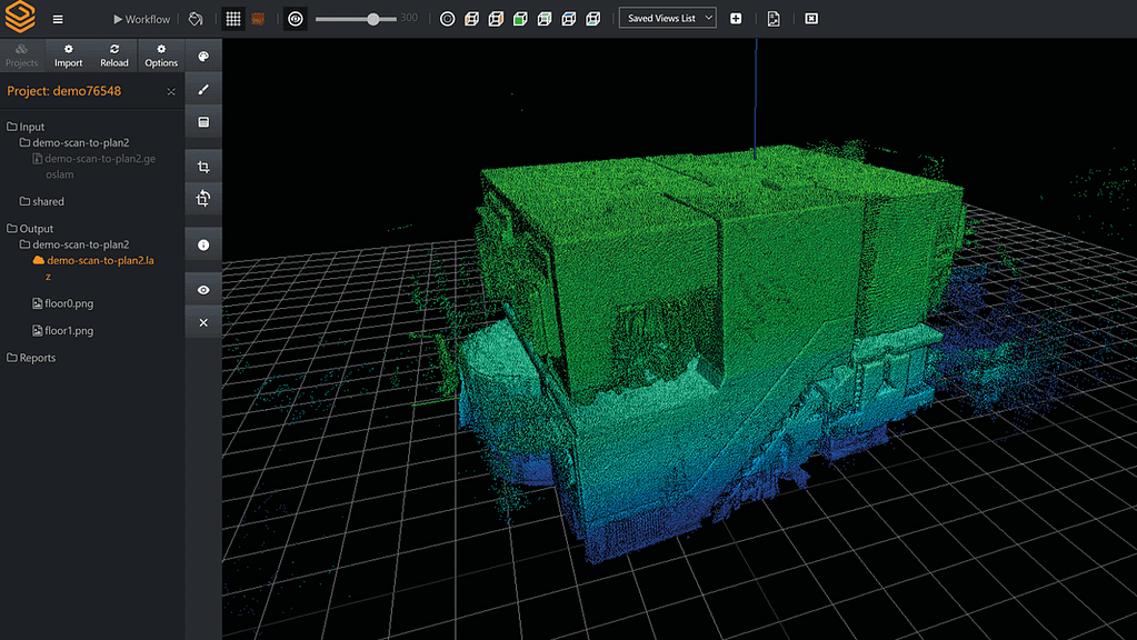
3D viewer
The Connect 3D viewer enables the user to create and manage projects, select the default processing workflow, create reports, and visualise data. SLAM results generated from automated workflows are viewable in the 3D viewer for easy visualisation and interpretation.
Point clouds can be coloured by time, elevation, RGB or a user defined single colour. Data captured using the GeoSLAM smartphone app (images and notes) can also be displayed in the 3D viewer as a series of ‘hotspots’ that the user can select to see the app data captured at the hotspot location.
Watcher folders
In addition to the 3D viewer, GeoSLAM Connect workflows can be configured to automatically run when new data arrives in a watcher folder. The watcher folder and workflow can be defined by the user. The workflow will run on any new data arriving in the watcher folder without any user interaction with the GeoSLAM Connect software.
Folder watchers are useful for applications such as remote field-to-office data transfer where data arrives over a network connection, is automatically processed, and stored on a server.

Point cloud filtering
As part of an automated workflow, point cloud filtering options can be defined. Options include point decimation as a percentage of points, distance between points and every nth point. Data can also be range filtered between a minimum and maximum distance from the scanner trajectory.

SLAM
GeoSLAM Connect provides full automation of SLAM data processing from all ZEB scanners. Commonly used data export options are stored as default workflows to simplify creating point clouds from .geoslam files. The user can also import multiple .geoslam files that are processed sequentially. Learn more about what makes our SLAM unique here.

Connect is a flexible software platform that automatically processes your .geoslam data, available with add on modules designed to make industry specific problems easier to solve.
Connect will be the basis for future software development, with a range of industry specific solutions being built within the Connect platform. Each module can be bought or licensed separately.
GeoSLAM Construction Progress
Construction Progress allows construction companies to scan their sites and automatically generate point cloud data in Connect. The data is then automatically compared to a BIM model or previous scan, providing the user with a percentage of completion figure for their project against a 3D model.
Track and Record Progress
Traditionally construction companies use inefficient, time consuming and subjective ways of tracking construction progress, such as; pictures, Whatsapp messages or word of mouth. Tracking and recording progress using a handheld SLAM scanner and GeoSLAM Connect gives a clear and objective perspective on the progress. In addition, by using the watcher folder, anybody within the company with access to the folder can quickly see the information without having to visit the site.
Anybody on site would be able to use a ZEB scanner, and with the automatic data collection taking minutes, it is an extremely quick and efficient way for site managers to get an accurate overview of what stage the construction project is at, leading us nicely into our second point.
Disputes
If you have ever worked for a construction company, you’ll know that delays can be costly, in both time and money, causing expensive disputes between contractors and building owners. Because scanning is so simple, contractors can do it as often as they like, to quickly get an idea if their projects are falling behind, thus saving them the hassle and cost of disputes.
Phone App
Don’t forget about our shiny new phone app! Whilst scanning a construction site, the user can take photos or make voice notes, which will later be translated into the pointcloud data. This is fantastic because it means the user can flag issues for the construction company to assess, without them having to visit the site so regularly. So, if the user feels a wall doesn’t look quite right, or something looks hazardous, they can note that within the pointcloud at the location the photo/voice note was made, for all to see.
Create a PDF
A digital record of site progress over time can now be captured, reported, and stored for the life of the project and beyond. You will have an easy-to-understand PDF report automatically generated and emailed to you or saved in a file location of your choice. The PDF report will show the percentage of work complete or incomplete (compared to 3D model) and a simple visualisation of the site highlighting 3D change. Consistent record keeping on this scale means that any future disputes around completed construction work can quickly be resolved!
Don’t just take our word for it – UK construction giants Willmott Dixon have been trialling GeoSLAM Construction Progress since 2020 with fantastic results. Here’s their digital manager, Maxine Beadle, talking about their experience so far.
GeoSLAM Floorplans
GeoSLAMs second add-on module is Floorplans. Floorplans takes creating 2D floorplans of real estate or commercial buildings to a new level. By simply scanning a building and loading the data into Connect, you can automatically have precise 2D floorplans in a matter of minutes. With 100 billions of dollars lost in income due to undervalued property globally, it’s easy to see why you would want quick and objective measurements of your property portfolios. One GeoSLAM client trialling Floorplans had this to say:
We discovered 240,000 additional square feet in a 12 million square foot portfolio using GeoSLAM.
Why GeoSLAM Floorplans?
GeoSLAM Care Customers
Are you a GeoSLAM Care customer? Great news! We’ll be in touch with you soon about setting you up with GeoSLAM Connect, though you don’t have to move from Hub. And if you like the sound of Floorplans or Construction Progress, you can request a free demo.

Payment Plan
The launch of Connect brings with it new ways to buy, with the launch of a payment plan. The payment plan is a great way to lower the upfront cost of ownership and spread it out over 24 months. Products that can be purchased under the payment plan include Scan to BIM, Floorplans and Construction Progress.
In the USA, any ZEB product can be bought.
Webinars
We’ve got a selection of exciting webinars coming up, where you can learn all about our new Connect based solutions, Construction Progress and Floorplans. Sign up to a webinar today.