Last Updated on 25th April 2022
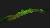
Scanning Grotte De Lombrives
as part of the Deep Time 40 experiment
Deep Time 40
For 40 days, 15 participants set up camp in the Lombrives cave in southwestern France with no clocks or sunlight, and zero contact to the outside world.
The Human Adaptation Institute conduct studies of real-life situations, solely on humans, to better understand the cognitive and physiological mechanisms of the human mind when facing rapid and long-term change. Their latest experiment, Deep Time 40, aimed to explore the links between the human brain and time, to gain insight into the limits of human adaptability to isolation.
The team entered the cave in March 2021 and emerged 40 days later. Most of the team were only on their 30th cycle when they exited the cave, showing that their perception of time had altered.
Why a SLAM scanner?
Traditional tripod-based systems used for digital mapping rely heavily on GPS to collect accurate data. SLAM technology, however, overcomes this limitation by cutting out GPS altogether, enabling scans to be carried out in complex and enclosed spaces, including underground.
In addition, a traditional scanner would have found it difficult, if not impossible, to traverse the cave in such a short period of time, due to the narrow spaces, as mentioned above.
“The study tested the limits of human endurance in a challenging environment and the same can be said of the technology to survey the Lombrives cave. Using traditional static and GPS-based scanners would have been impossible for this project, so we are delighted that the ZEB Horizon’s adaptability and ruggedness played its part in an historic piece of research”
Tomas Blaha
European Channel Manager, GeoSLAM
View the sample data here