Last Updated on 24th March 2023
Georeferencing is key for a Geographical Information System (GIS) to succeed with its ambitions to analyse and manage different types of data. Whether it’s remote sensing, imagery, or satellite data, georeferencing connects the information to a map displaying it in relation to its position in the real world.
This article provides an overview of the best ways and practices for georeferencing mobile LiDAR data, in preparation for import into GIS.
Georeferencing and Geographical Information Systems
Firstly, we should summarise what georeferencing and GIS are, why it is important, and who benefits from georeferenced data.
What is Georeferencing?
Georeferencing is a critical way to manage and analyse spatial data or information, by adding it to the real world. The technique involves aligning local raster data (such as a scanned map, data or digital image) to known latitude and longitude coordinates. This is best achieved with a minimum of 3 points of reference.
The reference points might refer to distinct elements of natural features in the world like rivers or man-made structures like roads or buildings. Alternatively, Global Navigation Satellite System (GNSS) receivers provide accurate coordinates, which can later match to local control points.
Geographic Information System (GIS) – what and why?
A geographic information system (GIS) is a computer-based approach to capturing, manipulating, analysing, and mapping different types of data. Here are some advantages of utilising GIS:
Scanned maps provide information over time
GIS aids users with the tools for better decision-making around location-based information. For instance, accurately monitoring the change of a landscape over time might be key for the mitigation of natural disasters like flooding.
Using geospatial data provides better visibility for decision-makers
GIS allows for the layering of different data to identify changes over time, review patterns, or examine issues that may not be apparent when reviewing each layer of data in isolation. Accurately placed data is a critical tool for managing and analysing spatial information in GIS.
Who typically georeferences data?
Geospatial experts georeference information for industries such as surveying, AEC, or cartography. Some specific use cases might include the following:
Environmental Monitoring
Tracking changes to an environment over time, for issues like deforestation. Understanding a landscape over time is key to informed decision making.
Natural Disasters
During a natural disaster, calling upon georeferenced data provides information to the extent of the issue, leading to better decision-making.
Urban Planning
Georeferenced data feeds into and informs decisions around transportation, housing or general infrastructure, as part of urban planning.
What is mobile LiDAR?
Light Detection and Ranging (LiDAR) is a technology that uses light beams from a laser to collect accurate measurements of an environment. Traditionally, LiDAR for mapping is found in terrestrial laser scanners and has formed part of a surveyor’s toolkit for the past few decades. As the name suggests, mobile LiDAR is a way of capturing 3D data with more mobility, for example handheld or via UAVs and vehicles.
How to georeference data using mobile LiDAR
Handheld SLAM systems don’t always have internal GNSS receivers to provide accurate coordinates, unlike some TLS. There is therefore a requirement for external methods to georeference data. Typically, this is done using pre-determined control points that are identified during a scan. Here are the 3 methods for accurately georeferencing data with mobile LiDAR:
1. Matching Reference and Control Points
Using a GNSS receiver, a minimum of 3 reference points are captured in the scan area. These points are known coordinates and a survey pin often identifies them. As a handheld LiDAR system performs a scan, like GeoSLAM’s ZEB Horizon, it is placed on the pins for a minimum of 10 seconds via the reference base. The scanner’s Inertial Measurement Unit (IMU) notes that the system has stopped for a prolonged amount of time and registers the point locally.
During the processing stage, the registered local points are automatically or manually synced with the known control points. The output is a georeferenced point cloud ready for use in a GIS.

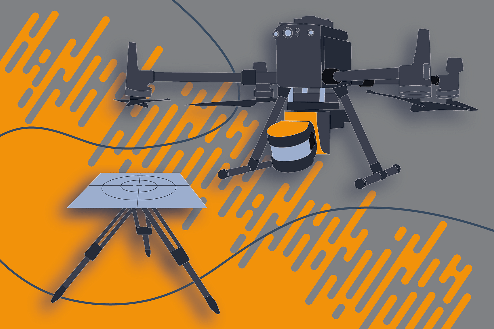
2. Reflective targets
Like the method above, georeferencing using a reflective target requires a minimum of 3 control points using GNSS. Placing the targets on the known control points gives users the freedom to move through their data without stopping. The targets give off higher intensity values due to the reflectiveness, and can therefore be highlighted within the processed scan. Combined with the pre-determined coordinates, software like GeoSLAM Connect will georeference the data in a simple automatic workflow.
Targets unlock the opportunity for georeferencing data captured with accessories like UAVs or vehicle mounts because there isn’t a requirement to stop.
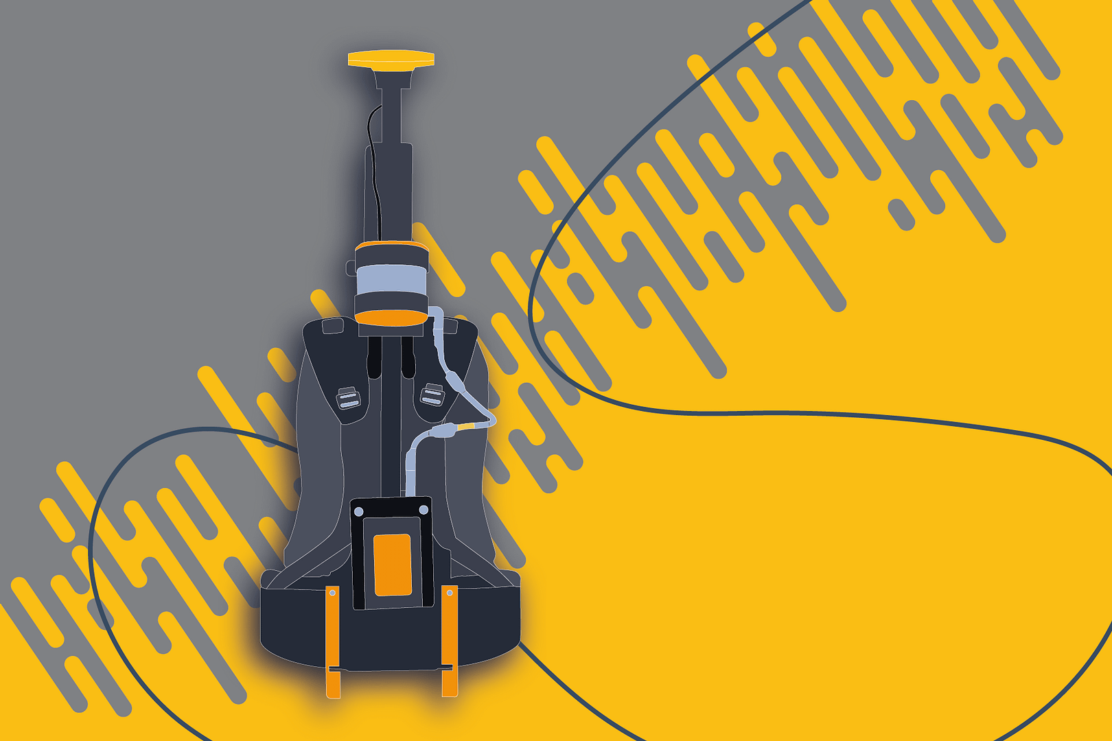
3. Using GPS on the move
The third and final way to georeference mobile LiDAR data is via a backpack and GNSS receiver. By capturing live GPS coordinates during a scan and matching the scanning and GNSS trajectories, you can simply georeference the resulting data. This is achieved first by running a course alignment, followed by a fine alignment for accuracy, and requires a minimum of 60% good GPS data.
This method is useful for those wanting to capture and georeference large datasets because it lends itself to open-loop scanning. GeoSLAM’s ZEB Locate is a great example of this in action.
Our tips for accurate georeferencing
Georeferenced data is only useful if it’s accurate. Here are some tips for getting a precise result.
Why is georeferencing important?
The main advantage of georeferencing data is to locate it in the real world. This provides a more accurate scale to the data. It’s also important for:
Comparison
Georeferencing is especially useful for comparisons against other geographic data and historical data.

Merging Data
It is easier to combine different forms of data together if they have been georeferenced; for example, satellite or aerial imagery with terrestrial laser or SLAM data.

Confidence
Georeferencing also improves the consistency, completeness and reliability of spatial data, providing a greater layer of confidence to decision-making.
How can GeoSLAM help
From satellite images to point clouds, using georeferencing to place data in the world opens up many new possibilities. Remotely sensed imagery is more useful if it’s used in conjunction with other data, so it’s often vital to anchor it in the world using geographic objects and coordinate systems.
GeoSLAMs hardware and software solutions are created with end user workflows in mind. For those wanting to georeference data, we make the process fast, simple and efficient via GeoSLAM Connect. The software offers automatic solutions for the ways to georeference mobile LiDAR highlighted above.
Fill in the form below to register an interest in our solutions, and book in a free demo.
Want to try GeoSLAM LiDAR for yourself?
Fill in the form below to register your interest.


