
The Advantages of LiDAR for calculating energy efficiency ratings
Last Updated on 29th June 2023 The Advantages of LiDAR when calculating… Read More »The Advantages of LiDAR for calculating energy efficiency ratings
Last Updated on 29th June 2023 The Advantages of LiDAR when calculating… Read More »The Advantages of LiDAR for calculating energy efficiency ratings
Last Updated on 7th October 2022 How LiDAR is being used in… Read More »How LiDAR is being used in Real Estate to map rooms and properties

Netherlands

Approx. 15 minutes per scan

Varies per scan

Residential & commercial properties

Real Estate
Real Estate is a fast-moving and highly competitive market. Companies are reliant on good customer relationships based on trust. They realise the importance of providing accurate measurements and specifications of the properties they are advertising. Buildings incorrectly measured could be under or overvalued, which could result in complaints, invalidate a sale, or damage their reputation.
This is particularly pertinent in the Netherlands, as they have placed a high level of importance on delivering accurate floorplans when advertising a property. In fact, a new regulation was introduced in 2010 after properties in Amsterdam were sold at a higher cost, after being overvalued due to incorrect floorplan measurements. The regulation, BBMI, requires businesses advertising properties to provide accurate floorplans or face potentially heavy fines.
This required businesses to think differently about how they could quickly and accurately assess the properties they were advertising.
Rotterdam based media and marketing company, ZIEN24, realised they needed to modernise how they measure properties in light of the regulations. ZIEN24 produces content and digital floorplans for estate agents, covering all types of residential and commercial properties.
The company began measuring properties using laser rangefinders, which were not only time-consuming but also not cost-effective. The company received complaints when properties were not measured within the limits of the regulation, and the team had to occasionally return to properties to re-measure them. In addition, ZIEN24 was sending both photographers and surveyors to properties, which was not cost-effective or ideal for their clients.
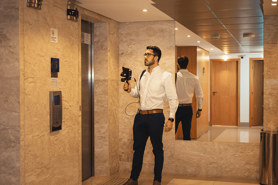
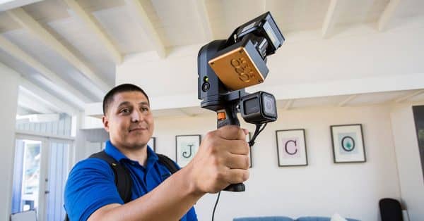
Having worked with point clouds previously, ZIEN24s co-owner, Boy Van Houten, thought that they could be the solution for accuracy. However, they needed a setup that was quick and effective, so static-based systems were not an option. After researching different scanner options, they decided to try GeoSLAM’s ZEB Revo RT with the ZEB Pano accessory.
The ZEB Revo RT is highly accurate, fast, and easy to use. As it requires minimal training, ZIEN24 taught their photographers to scan properties when they’re on location taking marketing photos. This negated the need for a surveyor, saving ZIEN24 money which could be passed on to their clients. The scanners accuracy largely removes the risk of human error, and ZIEN24 have not received any complaints since starting to use GeoSLAM scanners back in 2019.
The addition of the ZEB Pano allows them to take informative 360 degree panoramic photography, at a much quicker pace, during a scan. The ZEB Pano stores the exact location of each panoramic image within the scan, enabling more accurate and less intrusive property surveys. This is vital for ZIEN24, as the popularity of virtual house tours increases within the real estate industry.
The GeoSLAM scanner not only gives us confidence in the end product but gives our clients peace of mind knowing that our fully-automated measurements are highly accurate.
As the scanner captures in real-time, the photographers can easily ensure that they are capturing every room, as they walk around. Furthermore, the speed of capture, 200m2 in 15 minutes, means that more properties can be assigned to photographers per day. The data is then processed in their offices in China, and accurate floorplan reports are typically turned around within 24 hours.
The ZEB Revo RT has also helped them to expand into other markets, and they now offer scanning services to support BIM models.
If you’d like to learn more about how GeoSLAM solutions can help you, submit the form below.
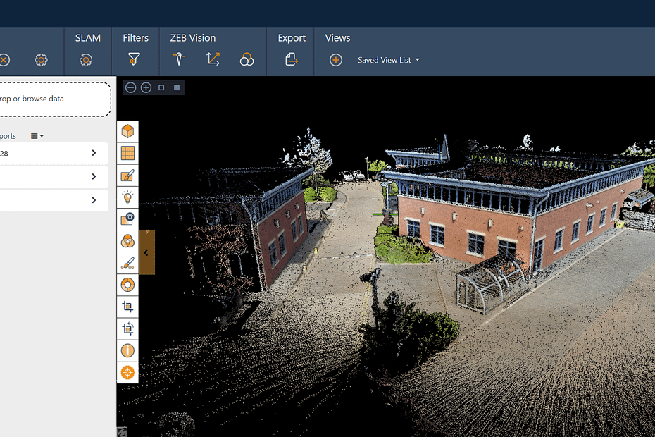
With ever-increasing research and development in the technology, the advances in both scanning hardware and processing software are improving the detail, scale and use of point cloud data. One of these improvements is colourisation. Adding colour has plenty of benefits when viewing and analysing point cloud data.
Location: United Kingdom
ZEB Scanner: ZEB Horizon
Scan time: 5 Minutes
Colourised data was captured using the ZEB Vision camera accessory.
Would you like to see a specific dataset that’s not on this page? Contact [email protected]
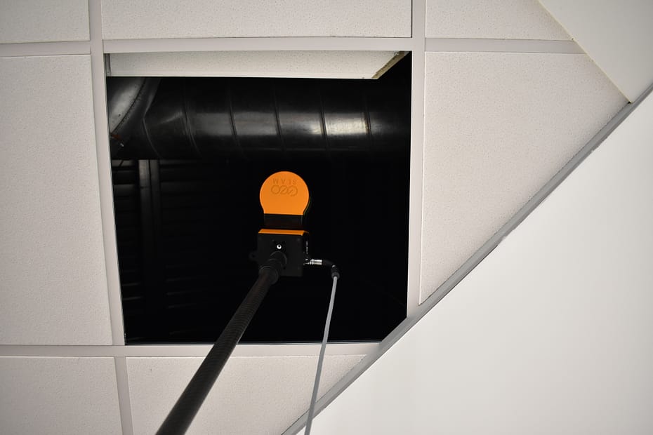
Surveying buildings is difficult and accessing hard to reach areas, like dropped ceiling or raised floors, without disrupting business can be seemingly impossible. In this blog we’ll discuss how SLAM and LiDAR technology has made scanning behind dropped ceilings a simple process.
Jim Foster has worked in the surveying industry for over 18 years, building a well-respected company with high profile clients from all over the United States. Originally the owner of a product design company, Jim saw the opportunity to begin a new adventure in the world of surveying and has never looked back.

SLAM scanning is becoming more commonplace in the surveying industry due to the ease of use, accuracy, and versatility of the handheld devices. As the technology continues to grow, so do the benefits of handheld scanning compared to traditional means of capturing the measurements of a building. Documenting large spaces is now as simple as walking around the property to capture a pointcloud, saving both time and money for surveyors and their clients.
With ever accelerating technological advances year on year, businesses across all sectors cannot afford to become complacent. We only have to think of companies who have failed to innovate and have been left behind as rapid digitalisation overtook their dated business models, with examples like Blockbuster and Kodak easily coming to mind.
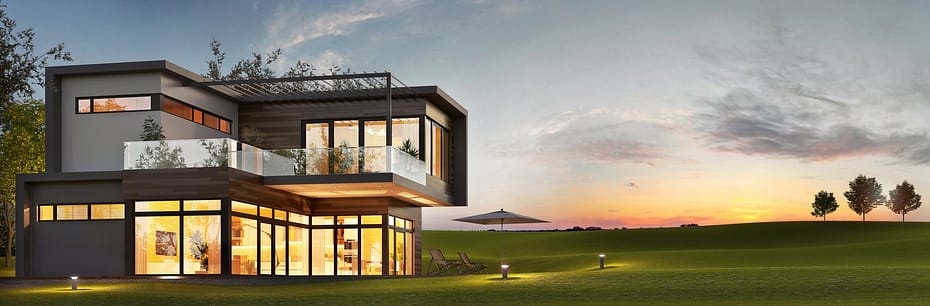
Real estate is not immune to technological advances and those that move to adopt new technology quickly enough, often end up being the biggest beneficiaries. Traditionally real estate businesses tend to fall behind when it comes to adopting new trends, however in recent years with the introduction of PropTech, more companies in this sector are exploring what technology could do for them.

PropTech funding between 2014-2019 has grown by 766%, and it is expected to continue.
The real estate sector is typically regarded as conservative when it comes to technology, but with a plethora of innovative technologies in recent years such as artificial intelligence, it has become hard to not take advantage of the opportunities being presented.

90% of all the data we now have in the world was created in the last few years.
With so much accessible information, businesses can easily gain valuable insights into their potential customers. A real estate business might be able to quickly pick up data on buying/selling trends or demographics in a local area etc. to determine the value of their properties.

45% of commercial real estate companies are spending 15% to 25% of their time organising and managing data.
With so many assets, keeping on top of data management for a commercial real estate company (CRE) is proving to be difficult. 60% of executives say their firms still use spreadsheets instead of software as their primary tool for reporting.
With a combined estimated worth of $50 trillion between real estate and commercial real estate, according to the federal reserve, it is clear to see why technology companies have been keen to showcase the benefits of recent technological advancements, in recent years. Though real estate has been significantly more keen to embrace new technology, CRE hasn’t seen the same level of adoption.
The supply and creation of new, digital tools to manage large property portfolios are coming of age, with viable PropTech solutions on the market that integrate with and enhance their current ways of working. If CREs aren’t already looking to digitalise, now is the time.
When it comes to maximising the value of property, those in CRE consider many factors, but what is often overlooked is inaccurate measurements of their properties due to human error or underestimating how much the floorplan of a property has changed and adapted over time. In fact, $100 billions are lost globally due to undervalued property. Embracing technological solutions like SLAM laser scanning can give CREs rapid, repeatable and highly accurate measurements and floorplans of their properties, without needing to outsource or rely on dated information.
There is a great deal of paperwork involved in CRE management, and not having a digital record is not only inefficient, but it can also be costly. Having all the documents in an easy to access digital library can be helpful when needing to access paperwork quickly. Whether you’re trying to sell your property, or you need to deal with an audit etc. having a centrally stored digital record of your portfolio can help minimise workload and maintain good standards of information keeping.

“Too many companies are prepared to put up with poor-quality data when it is entirely in their power to improve it” – RICs
With technological solutions now available for repeatedly capturing and keeping data up to date quickly and easily, CRE companies no longer need to rely on old data, ultimately saving them money.

Early adopters of new technology often pave the way for others to follow in their footsteps, however those that end up following often play catch up.

The introduction of 3D digital models has been revolutionary for many sectors, including real estate. This digitised advancement means better planning and execution of real estate projects.

Technology makes processing and storing complex data incredibly easy, making estimations of property value more accurate.

Virtual tours of properties have significantly reduced the distances between a buyer and seller. Somebody in the USA could now purchase a property in the UK without having physically set foot in the building.
With the advancements of digital technology comes the shift to online marketing. Traditionally selling real estate was the sole task of real estate agents, however 47% of companies in 2018 acknowledged that their highest quality of marketing leads came from social media.

As technology is intertwined into our everyday life now more than ever, it’s shouldn’t be a shock that people buying property want their homes/buildings interconnected. Real estate buyers know this, and have begun investing and developing technologically optimised buildings for the buyers of tomorrow.
Over the past few years, we have been working with real estate companies to make it easier to understand buildings. Combining the use of our handheld SLAM scanners and new intuitive software, GeoSLAM Floorplans was born. In a few simple steps, CRE companies can now have accurate measurements of their buildings, in often large building portfolios, and they completely own the data with no monthly costs to store the data. As a result, CRE companies are able to maximise their property value and have easy to read digital records of their assets.
Want to learn more about GeoSLAM Floorplans and how it could transform your business? Submit the form below and we’ll be in touch.

As the adoption of SLAM rockets, and new applications for mobile data capture are discovered each day the value of SLAM is being proven across businesses of all shapes and sizes. GeoSLAM technology continues to break barriers and the ever-increasing profile of SLAM users grows each day.
Location: N/A
ZEB Scanner: ZEB Go
Scan time: 20 Minutes
Would you like to see a specific dataset that’s not on this page? Contact [email protected]
Last Updated on 25th April 2022 The real estate market is fast-moving… Read More »GeoSLAM helps leading media company Zien24 revolutionise their digital workflow

Known control points are captured during a scan and automatically compared and matched to the associated coordinates during the processing stage in Connect. A rigid and/or a non-rigid adjustment can be made to the dataset and an accuracy report is exported, highlighting how successful the transformation was. Users can now view and manipulate the processing parameters to ensure a more accurate match between points.

Align multiple scans using a combination of manual and automatic processes. This workflow can be performed on two or more scans in the same project. Users have a choice to export the aligned scans separately or as a single merged point cloud.

Common data capture scenarios, such as UAV, outdoor, indoor, linear, and vehicle, have been characterised in Connect and data processing pre-sets for each environment have been defined. These can be selected at the beginning of the data processing stage allowing this process to be highly simplified.

Both methods match the scan data from a ZEB Locate system with the GPS data collected from the antenna to georeference the point cloud. When a scan starts and ends in the same place, this is classed as “closed loop”. “Open loop” is when the start and end position of a scan are in different locations. Standard SLAM practices apply to both methods of data collection.
Open Loop SLAM for the ZEB Locate is available on request – let’s talk about it.

Common static points are captured during several scans meaning that these datasets can be automatically aligned. A single point cloud is then exported as if the data was captured in a single scan.

Horizontal and vertical slices can be taken from any location within the point cloud. Horizontal floor slices can also be automatically taken at a given height above the floor as defined in the processing stage.

Mostly used in the construction industry, multiple point clouds can be compared and any areas that have changed are automatically highlighted. Point clouds can also be compared with CAD models – for instance to track progress on a construction site – and PDF reports can be generated to present this information.


Some SLAM software algorithms have been made available as open-source on the internet, but they are purely algorithms and not a product that you can take and use off-the-shelf. SLAM is most successful when it is tightly coupled and designed with specific hardware in mind. A generic SLAM cannot perform as well as one that has been specifically designed for a purpose.

Visual SLAM is closer to the way humans navigate the world, which is why it’s popular with robotic navigation. But in the same vein, vSLAM will have the same image-capture challenges as humans do, for example not being able to look into direct sunlight, or not having enough contrast between the objects picked up in the image. These can be overcome indoors, however, you may need to map a forest, tunnel or urban canyon. While SLAM technologies don’t rely on remote data (meaning you can scan areas where there is no GPS), you do need to ensure the SLAM technology you chose operate well inside, outside, in daylight and darkness.

Mapping a property is time-critical. Ideally, you want to make a single visit and gather sufficient data to create a highly accurate 3D model. Ensure the software you choose transforms 3D point cloud data into actionable information in real-time. This allows you to view and interrogate your data whilst still in the field, and make any adjustments, or collect missed data, then and there.

If you’re trying to map an enclosed environment (e.g. tunnel, mine) or a complex, difficult-to-access space such as a heritage building with tight stairwells and uneven floors, you need to use fully-mobile, adaptable technology. Wheel-based systems, often used with the vSLAM camera, will struggle with access. Handheld devices or LiDAR scanners that can be attached to a drone or pole and still deliver accurate results in a rugged environment are best for navigating hazardous spaces.

While vSLAM is able to provide a qualitative high-level map and sense of the surrounding features, if you’re needing survey-quality accuracy and rich-feature tracking at a local level, you’ll need to consider LiDAR. Cameras require a high-frame-rate and high processing to reconcile data sources and a potential error in visual SLAM is reprojection error, which is the difference between the perceived location of each setpoint
and the actual setpoint.

In order to deliver the depth required for high-quality data, a number of depth-sensing cameras are needed with a strong field of view. In most cases, this isn’t possible, especially as cameras with high processing capabilities typically require larger batteries which weigh down airborne scanners, or limit the time of flight. LiDAR is both faster and more accurate than vSLAM, and can deliver detailed point clouds without expensive (and timely) camera processing.