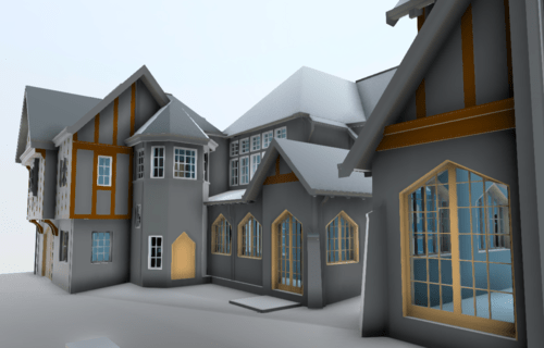
How Can We Use Laser Scanning For Historic Preservation?
Last Updated on 25th April 2022 How can we use laser scanning… Read More »How Can We Use Laser Scanning For Historic Preservation?
Last Updated on 25th April 2022 How can we use laser scanning… Read More »How Can We Use Laser Scanning For Historic Preservation?
Last Updated on 25th April 2022 What is LiDAR data What is… Read More »What is LiDAR data
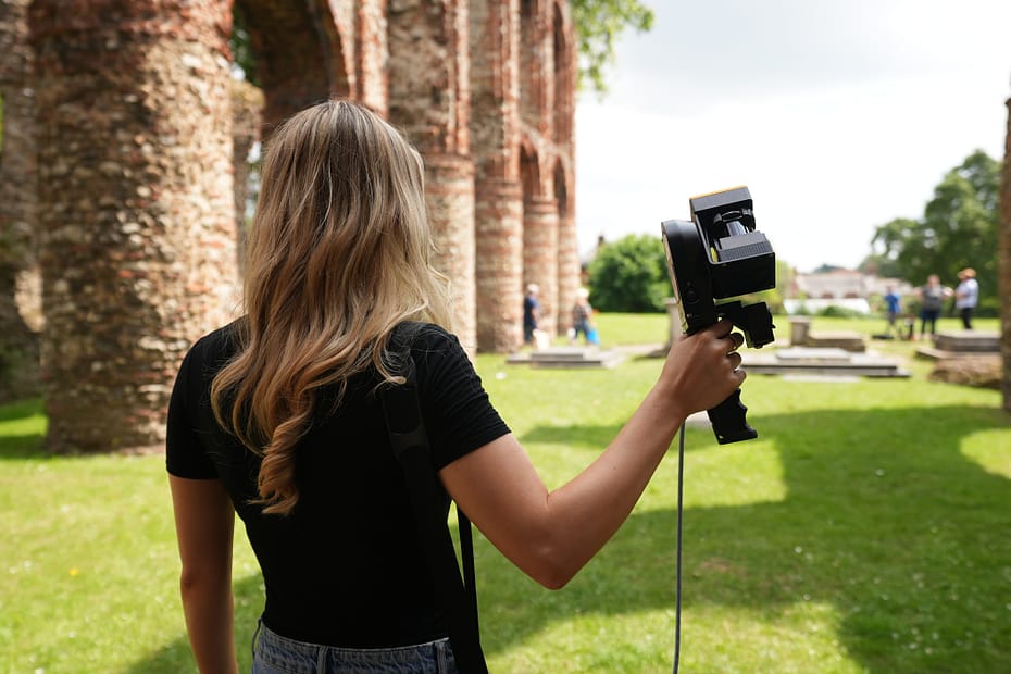
Location: Essex, UK
ZEB Scanner: ZEB Revo RT
Scan time: 20 Minutes
This data was captured as part of GeoSLAM’s Big SLAM Tour in 2021. Click here to learn more about the scan
Would you like to see a specific dataset that’s not on this page? Contact [email protected]
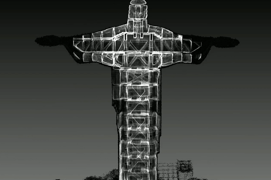
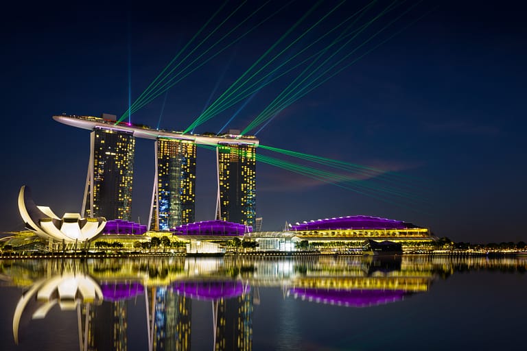
Location: Europe
ZEB Scanner: ZEB Revo RT
Scan time: 20 Minutes
GeoSLAM’s ZEB Pano was used to capture images of the distillery.
Would you like to see a specific dataset that’s not on this page? Contact [email protected]
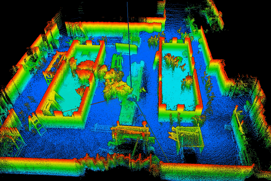
GeoSLAM were invited by Willmott Dixon to be involved with the beginning of this process, by scanning the existing used timber units provided by Carter Accommodation. Using the ZEB Revo RT, Willmott Dixon were able to capture data of all 4 cabins, in 4 minutes, registering over 8 million number of points.
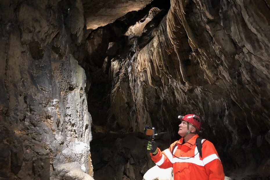
Chartered land surveryors, GeoTerra were invited by the BCRA (British Cave Research Association) to scan the cavern, so they could gain a better understanding of the geological formation. Using GeoSLAMs ZEB Horizon, GeoTerra’s goal was to map both areas accessible to the public and the narrow spaces just big enough to crawl through – a system of caves measuring 300metres long and 50metres wide.
Jim Foster has worked in the surveying industry for over 18 years, building a well-respected company with high profile clients from all over the United States. Originally the owner of a product design company, Jim saw the opportunity to begin a new adventure in the world of surveying and has never looked back.


Industry
AEC
Time
100 hours
Location
Singapore
Size
376 ground
floor void
decks
Scanned
Apartment
blocks
Singapore is home to some of the most profitable financial services, manufacturing and oil-refining corporations in the world. But with its accomplishments come some very specific challenges for a city-state which is limited by space but still demanding growth.
Determined to future-proof Singapore’s success, the country has embarked on one of the most ambitious digital twinning projects the world has ever seen – creating a dynamic 3D city model and collaborative data platform, including 3D maps of the region.
At the initial stage of the project it quickly became apparent that aerial imagery alone would not be able to capture ‘void decks’ – open spaces typically found on the ground floor of the city’s apartment blocks. These areas, which are sometimes underneath the tower block structure, are used for everything from games areas, bicycle parking, hosting wedding receptions and wakes, and, as estates grow, facilities such as shops, medical centres and even schools.
In the face of fierce competition, GeoSLAM’s ZEB Revo was selected as the most innovative and efficient solution to collect data from these important community spaces.
“A huge time saving exercise which would ordinarily have taken 40 times longer using traditional surveying methods“
With a handheld “go-anywhere” ZEB Revo, field teams quickly captured a dense and accurate point cloud of an entire void deck, which was then used to model the deck geometry and incorporate this into the existing building models.
376 buildings with void decks were scanned using the ZEB Revo, taking approximately 100 hours – an enormous time-saving exercise which would ordinarily have taken up to 40 times longer using traditional surveying methods.
The ZEB Revo is often used alongside terrestrial hardware as the products are highly complementary. The data output can be easily combined through geo-referencing or scan-to-scan matching and then used to build complete 3D models. In this instance, the combination delivered highly detailed and rapid results while significantly minimising costs too.
Industry
Asset
Management
Time
1 hour
scanning
total
Location
New
Brunswick,
Canada
Size
3,000 ft
Scanned
Hydroelectric
dam
Canadian 3D geospatial experts Smarter Spaces engaged in a partnership with the University of New Brunswick (UNB) to laser scan a tunnel in a hydroelectric dam – producing a point cloud model to be overlaid with photogrammetry.
The Grand Falls Generating Station is a hydroelectric dam built in 1931 on the Saint John River in the Canadian province of New Brunswick and is operated by the NB Power corporation. The dam’s tunnel is shut down every 4 years for maintenance, inspection, and future life cycle planning.
This presented Smarter Spaces with the opportunity to utilise the mobile, handheld GeoSLAM ZEB Revo to scan the tunnel – creating an accurate point cloud model. In four years’ time the process will be repeated – allowing for the first side-by-side comparisons of the tunnel’s performance to be made.
In addition to this, NB Power has started exploring whether to build a 100-megawatt generating station in Grand Falls to produce more clean energy. The corporation is carrying out environmental and geotechnical studies, site tests, and consultations with First Nations and local residents before applying for an Environmental Impact Assessment later this year.
“It was a simple case of ‘walking and scanning’ through the tunnel environment“
The tunnel is approximately 3,000 linear feet in length and, because of its unique geometry, proposed an interesting set of challenges to scan. The tunnel environment was found to contain a lot of moisture – with a small stream running through the base. The IP67-rated ZEB Revo – which began life in mining environments – is rugged enough for such environments. The tunnel was dark, visibility was low, and walking conditions were slippery and wet. Smooth-sided surfaces also cause data collection issues for mobile scanners.
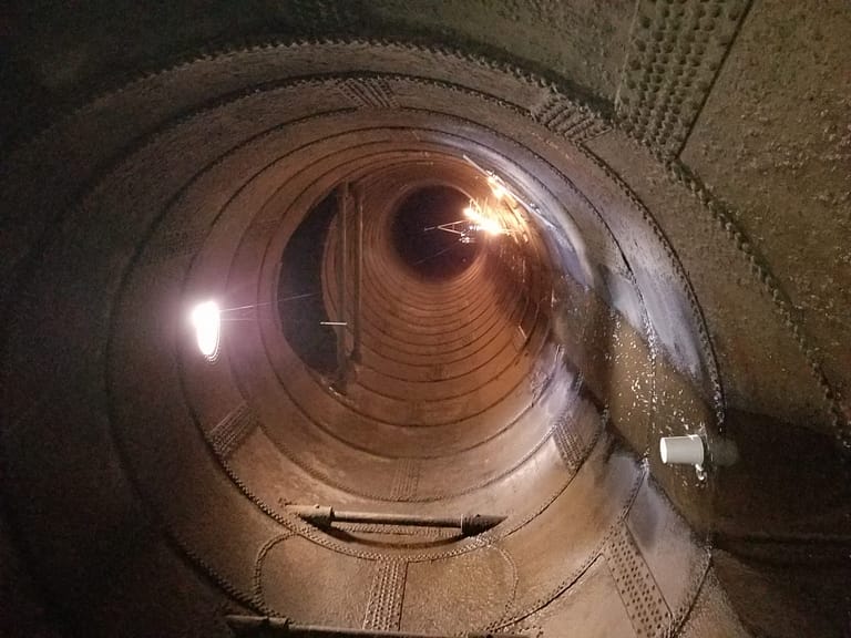
To overcome the risk of data slippage, 4 foot-high pylons were placed every 10 feet in random locations throughout the tunnel. This has the effect of ‘breaking up’ the monotony of the smooth-sided tunnel walls, ensuring that no data slippage occurs.
The scan data was processed in GeoSLAM Hub software to filter, subsample and merge multiple data sets together. The final models and datasets were sent to the University of New Brunswick to support an engineering graduate with their thesis research.
Industry
Surveying
Time
2.5 hours
Location
California,
USA
Size
20,000 sq/ft
Scanned
Private
residence
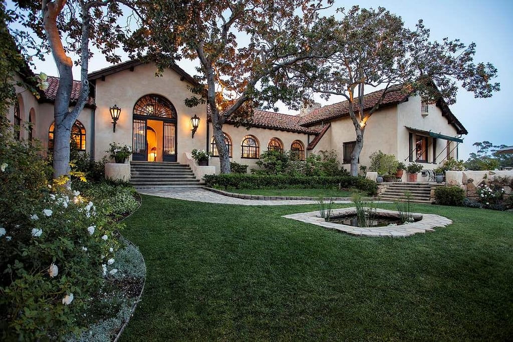
Precision Property Measurements | Words by Greg Davis
“We were tasked with surveying a vast private house in order to generate accurate as-built construction drawings for renovation. The unique challenge was that the 20,000 sq. ft Santa Barbara residence was occupied at the time, requiring the survey to be completed quickly and in an unobtrusive manner.
PPM (Precision Property Measurements) chose the ZEB Revo over other terrestrial scanners for our residential projects because of the speed and volume of data acquisition at exactly the level of accuracy required by our clients.
In order to keep disruption to residents to a minimum, we decided to tackle the task in two swift scans over two days. The first scan consisted of data collection of the extensive ground floor and communal areas, and took around 90 minutes to complete. The private, bedroom wing was off limits on this day.
The second scan incorporated these sleeping quarters, as well as gathering plenty of overlap from the lower floors to enable the 2 scans to be merged. After just 140 minutes of scanning, the entire house had been surveyed.
“We’ve always been confident in our ability to keep our projects to the nearest inch or less. In bringing the ZEB REVO into our arsenal of tools, we’ve kept the accuracy we’ve always had, but introduced an efficiency that allows our experts to get out there and do more for our clients“
A typical residential property of this size would have usually taken around 4 days on-site for one surveyor. PPM were able to slash this time and complete the majority of the survey work in less than 2 and a half hours with the ZEB Revo.
The use of GeoSLAM Hub software for post-processing and merging of the two datasets allowed the project team to generate a complete digital twin of the complex structure. GeoSLAM’s cutting edge mobile mapping technology was able to deliver an accuracy down to the nearest inch.
Industry
Architecture
Time
10 hours
Location
Belo Horizonte,
Brazil
Size
8,357 sq/m
Scanned
Skyscraper
Paragram | Words by Jose Vargas
“In the city of Belo Horizonte, there is a distinct mix of contemporary, classic and historic buildings on display, making it a really attractive destination to visit. What comes with the architecture on offer however, is the need to preserve it for tourists and future generations to enjoy.
Often the fragility of buildings or lack of resources means that many buildings go untouched for decades, leaving them to crumble. It’s my job to ensure these relics remain.
When the chance to retrofit electrical installations and a fire prevention plan to a 130-metre art deco skyscraper, the Acaiaca Building, became available, the team at Paragram knew we had to be involved.
“We were very impressed with the quality of information captured by the ZEB Revo.“
Built in the 1940s and once used as a nightclub, cinema, shops and air-raid shelter, the building required some attention in order for it to meet safety standards. Having initially planned to measure the 8,357 square metre building using manual survey methods, estimates told us this would have taken three employees over 40 hours to complete an as-built structure.
Working alongside contractors at Criar Projetos E Consultoria, Paragram decided to use GeoSLAM’s ZEB Revo, known for its ability to quickly generate images to within a few centimetres of accuracy. With the handheld device, the job was expected to take around 10 hours in total, reducing the workload dramatically.
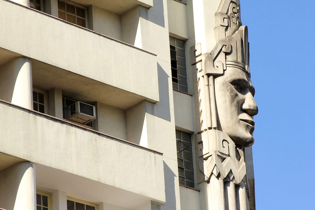
With just two operatives and in under 10 hours, we managed to complete a scan of the building’s interior, with one walking through the building holding the device and another taking a photographic record. This innovative way of working meant we were able to gather much more information than first anticipated, including the registration of beams and roof trusses, electrical installations and engine room areas.
“The ZEB Revo is a real game changer for the architecture industry.“
As a team, we were very impressed with the quality of information captured by the ZEB Revo, which was easily incorporated into a BIM representation using Revit software.
Almost every renovation project is governed by strict time constraints, but with GeoSLAM’s device and its ability to rapidly scan large areas, it is a real game changer to our industry. With products like this at our disposal, I am excited about what the future will hold for heritage buildings in need of a little TLC.

Industry
Conservation
Time
48 hours
Location
Various,
Israel
Size
Three sites
across Israel
Scanned
Historic Sites
Oxford Archaeology | Words by Jamie Quartermaine
“48 hours to scan three historic sites in Israel – ambitious or impossible? Equipped with a handheld 3D mapping device from GeoSLAM, we were determined to find out. Our first stop was the Schneller building in Jerusalem. In its 160 year history it has been used as an orphanage, barracks and ammunition arsenal. A few years ago, an archaeological team unearthed the remains of a Roman bath house and winery underneath the site. The next stage of the building’s history is a conversion into a museum of Judaism – hence the requirement for a complete, high-accuracy survey of the site.
Made up of four floors, 130 rooms, an outer courtyard and a number of stables, we needed to work quickly to scan the entire site. Using the handheld ‘go-anywhere’ ZEB Revo, in three – 30 minute scans he captured the entire building, including survey control points to georeference the data. Using traditional scanners, this would have taken several weeks and involved multiple set-ups.
“With the ZEB Revo, what use to take weeks can now be done in hours“
Next stop was an elegant and beautiful 12th century Benedictine monastery. With no more than 30 minutes between the end of the Vespers – the evening service – and the time when the public would be allowed into the monastery, we carried out a quick reconnaissance and accurately captured the unique domed building, only possible using GeoSLAM’s ’go-anywhere’ device.

Final port of call was a delapidated 19th-century merchant house in the ancient Arab town of Jaffa. The challenge here was to record the building while construction works were in progress, with hoardings and scaffolding obscuring structures. A near impossible task, but the ZEB Revo was still able to collect survey-grade data in a matter of hours, which formed the basis of a working record of elevations, sections and plans.
In under 48 hours Jamie had captured highly accurate 3D images of 3 heritage buildings. Proof indeed that with the ZEB Revo, what used to take weeks can now be done in hours.


Known control points are captured during a scan and automatically compared and matched to the associated coordinates during the processing stage in Connect. A rigid and/or a non-rigid adjustment can be made to the dataset and an accuracy report is exported, highlighting how successful the transformation was. Users can now view and manipulate the processing parameters to ensure a more accurate match between points.

Align multiple scans using a combination of manual and automatic processes. This workflow can be performed on two or more scans in the same project. Users have a choice to export the aligned scans separately or as a single merged point cloud.

Common data capture scenarios, such as UAV, outdoor, indoor, linear, and vehicle, have been characterised in Connect and data processing pre-sets for each environment have been defined. These can be selected at the beginning of the data processing stage allowing this process to be highly simplified.

Both methods match the scan data from a ZEB Locate system with the GPS data collected from the antenna to georeference the point cloud. When a scan starts and ends in the same place, this is classed as “closed loop”. “Open loop” is when the start and end position of a scan are in different locations. Standard SLAM practices apply to both methods of data collection.
Open Loop SLAM for the ZEB Locate is available on request – let’s talk about it.

Common static points are captured during several scans meaning that these datasets can be automatically aligned. A single point cloud is then exported as if the data was captured in a single scan.

Horizontal and vertical slices can be taken from any location within the point cloud. Horizontal floor slices can also be automatically taken at a given height above the floor as defined in the processing stage.

Mostly used in the construction industry, multiple point clouds can be compared and any areas that have changed are automatically highlighted. Point clouds can also be compared with CAD models – for instance to track progress on a construction site – and PDF reports can be generated to present this information.


Some SLAM software algorithms have been made available as open-source on the internet, but they are purely algorithms and not a product that you can take and use off-the-shelf. SLAM is most successful when it is tightly coupled and designed with specific hardware in mind. A generic SLAM cannot perform as well as one that has been specifically designed for a purpose.

Visual SLAM is closer to the way humans navigate the world, which is why it’s popular with robotic navigation. But in the same vein, vSLAM will have the same image-capture challenges as humans do, for example not being able to look into direct sunlight, or not having enough contrast between the objects picked up in the image. These can be overcome indoors, however, you may need to map a forest, tunnel or urban canyon. While SLAM technologies don’t rely on remote data (meaning you can scan areas where there is no GPS), you do need to ensure the SLAM technology you chose operate well inside, outside, in daylight and darkness.

Mapping a property is time-critical. Ideally, you want to make a single visit and gather sufficient data to create a highly accurate 3D model. Ensure the software you choose transforms 3D point cloud data into actionable information in real-time. This allows you to view and interrogate your data whilst still in the field, and make any adjustments, or collect missed data, then and there.

If you’re trying to map an enclosed environment (e.g. tunnel, mine) or a complex, difficult-to-access space such as a heritage building with tight stairwells and uneven floors, you need to use fully-mobile, adaptable technology. Wheel-based systems, often used with the vSLAM camera, will struggle with access. Handheld devices or LiDAR scanners that can be attached to a drone or pole and still deliver accurate results in a rugged environment are best for navigating hazardous spaces.

While vSLAM is able to provide a qualitative high-level map and sense of the surrounding features, if you’re needing survey-quality accuracy and rich-feature tracking at a local level, you’ll need to consider LiDAR. Cameras require a high-frame-rate and high processing to reconcile data sources and a potential error in visual SLAM is reprojection error, which is the difference between the perceived location of each setpoint
and the actual setpoint.

In order to deliver the depth required for high-quality data, a number of depth-sensing cameras are needed with a strong field of view. In most cases, this isn’t possible, especially as cameras with high processing capabilities typically require larger batteries which weigh down airborne scanners, or limit the time of flight. LiDAR is both faster and more accurate than vSLAM, and can deliver detailed point clouds without expensive (and timely) camera processing.