Surveying Interior and Exterior Environmental Features

Location
Kansas,
USA

Scan time
Approx. 20 minutes per scan

Size
Over 1 million sq/ft per year

Scanned
Buildings and Underground Oil Tanks
Industry
Surveying
Collecting Accurate Measurements of Buildings for the Military
The Kansas Adjutant General’s Department coordinates resources for local, state, and federal use. They also develop internal use documents for the military, including surveying building interiors to create up-to-date and accurate floorplans for military members within Kansas.
They have about 35 sites throughout the state, with some locations 100s of miles away from the headquarters. Further, the Adjutant General’s Department manages approximately 250 buildings state-wide, totaling around 2 million sq. ft. of interior space. These factors have led to some difficulties in keeping up with projects, and any changes to the buildings and layouts.
The team found that when remodelling buildings, they were having issues getting as-builts completed in time. As-builts are documents that are used to compare a building’s design plan versus its final measurements. They also provide accurate blueprints of the building, and the surrounding land, as actually constructed at the end of the project.
Being able to have one person go out to capture all of the data and have the most current floorplans, along with the accuracy of the scanners is a gamechanger
Kansas Adjutant General’s Department Use of the ZEB Revo
Scanning Properties to Keep on Top of Changes Made
To tackle these issues, the team decided to adopt LiDAR laser scanning technology to aid them in their projects and found GeoSLAM’s ZEB Revo to be the best option. By acquiring GeoSLAM’s technology, the Kansas Adjutant General’s Departments’ goal was to scan over half of their 2 million sq. ft. of interior space every year.
The ZEB Revo is handheld, accurate and fast, providing the team with a perfect tool. In addition, the simplicity and ease of use means only one team member needs to travel to a site, when necessary. Previous methods of data capture were not as quick or accurate. The ZEB Revo data capture leads to a faster return on projects, higher levels of accuracy, and a high return on investment.
By using the ZEB Revo, the Kansas Adjutant General’s Department have updated over 1 million sq. ft. of interior space, achieving their overall goal, with just one technician visiting half of the sites per year. The speed of capture of the ZEB means that the average time it takes the team to carry out a scan is just 20 minutes. By collecting accurate measurements, they can now regularly update their GIS database, which provides up to date floorplans throughout the state.
Data from the ZEB Revo is also used to create ‘X-Ray’ views of their properties for future plans and layouts.
Collecting Accurate Measurements with the ZEB Horizon
Recently, they have expanded their use of handheld LiDAR technology by acquiring a ZEB Horizon, which they use for a variety of reasons. The increased range and data capture points make the ZEB Horizon a great option for large exterior scanning. This is important to the Adjutant General’s Department as they cover land of up to 50 acres.
Scanning Environmental Features to Work out Contour Lines
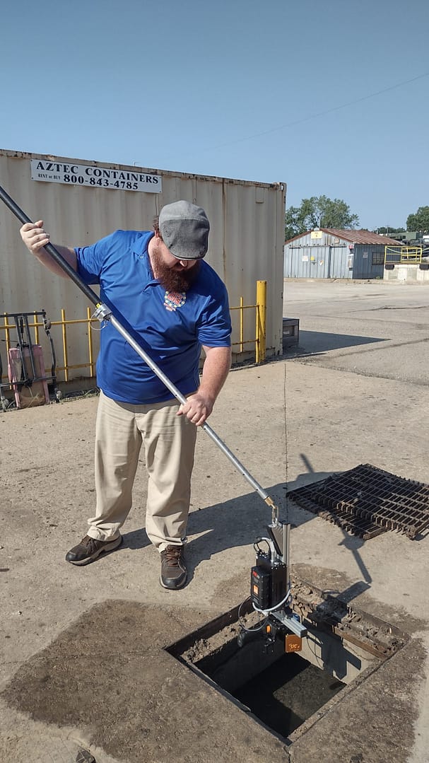
The Kansas Adjutant General’s Department also have tanks that contain hazardous material which they need to track carefully. Using the ZEB Horizon, they scan exterior environmental factors to figure out contour lines within their complex. This helps them work out where any spillages of hazardous material would be, should one occur.
Using the ZEB Horizon to Ensure Current Asset Management
With the ZEB Horizon, the team also carry out exterior scans for asset management. Due to the scanners ease-of-use, one engineer can attach it to a truck and drive around their complex. This enables Kansas Adjutant General’s Department to scan their entire site and keep on top of their buildings and resources.
The team are also looking to expand this by attaching the ZEB Horizon to a UAV in the future.
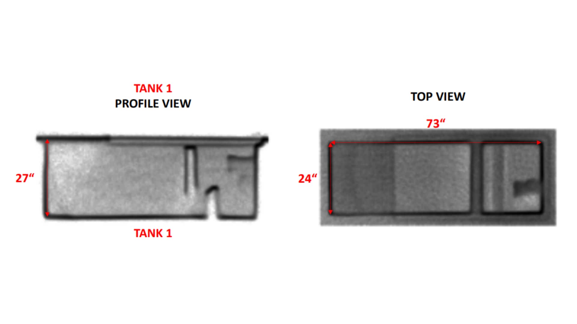
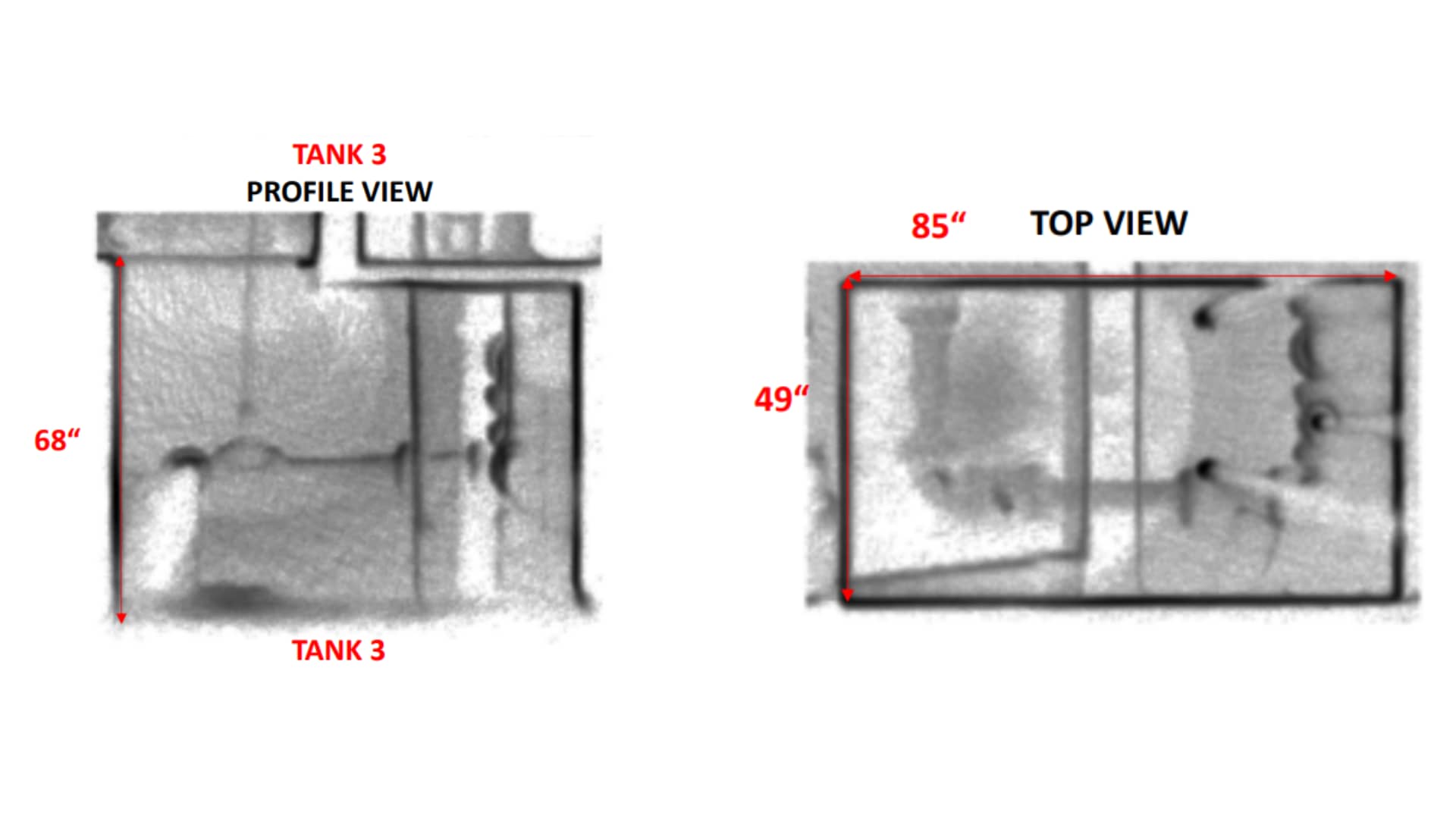
Collecting Accurate Measurements of Underground Oil Tanks
The ZEB Horizon’s time saving, and accurate scans have proven to be a cost-effective method of data capture. For example, scans of underground empty oil storage tanks showed that the Kansas Adjutant General’s Department had been over estimating the tanks collection capacity, leading to an adjustment of the servicing contract.
Processing Data into Point Clouds and Third Party Integration
Since The Kansas Adjutant General’s Department acquired GeoSLAM’s technology four years ago, they have carried out approximately 2000 scans, and this number continues to rise.
Further, the contractors and architects that create as-builts are now using The Kansas Adjutant General’s Department to quality check their work for accuracy. Using GeoSLAM laser scanners, they help find errors in specifications and relay that information to the contractors.
With the help of Seiler Geospatial Division, Kansas Adjutant General’s Department have been able to significantly improve their workflow. To find out more about Seiler, click here.
Get in touch
If you’d like to learn more about how GeoSLAM solutions can help you, submit the form below.


