Virginia Tech scan WW1 battlefield terrain in France

Location
Vauquois, France

Scan time
Three times faster than terrestrial scanners

Size
Several Kilometers

Scanned
Battlefield Tunnels

Industry
Education
Mapping WW1 Tunnels in Vauquois, France
The Vauquois battlefield in France tells a little-known story of mining warfare during World War I. This area went through 4 years of combat which saw the hilltop village of Vauquois completely destroyed. In addition, French and German troops dug miles of tunnels under each other’s positions. This meant they could plant explosive mines to ‘bomb’ the enemy from below. Consequently, this bombing left underground WWI tunnels in Vauquois.
The WWI tunnels in Vauquois must be experienced first-hand to understand the difficulties and despair of living deep underground. Moreover, in wet, cold and cramped conditions for days at a time. Of course, not everyone can travel to France and crawl through the remaining tunnels in person. A group of researchers at Virginia Tech brought the battlefield to classrooms and museums with the help of reality capture and virtual reality (VR) technologies.
The WWI Tunnel’s Extensive Cramped Spaces
Combining efforts of the University Libraries, the Department of Visual Arts and numerous other disciplines, the Visualising History team travelled to Vauquois with funding from a federal grant in 2016. Over 10 days, they used traditional static scanning methods to capture details of the battlefield terrain.
However, when they attempted to scan inside the tunnels, their progress slowed down considerably as there were tight spaces that their scanners could not get into, which made the data capture process extremely time-consuming.
Scanning difficult to access areas with the ZEB Horizon
Before their next trip to France, the team acquired a 3D handheld laser scanner, GeoSLAM’s ZEB Horizon, with the hopes of making their time on-site more time efficient.
Due to the ZEB Horizon’s ease of use and speed of capture, the team collected scan data inside the tunnels more than three times faster than with the traditional stationary scanner. The time it took to scan the tunnels was crucial, as they were working on a budget, and the ZEB Horizon enabled them to do more with the time and money they had available. They also used the ZEB Horizon above ground, scanning the narrow trenches, wide bomb craters, and a church foundation.
The ZEB Horizon also proved to be more efficient as its software processes the data into a point cloud quickly. This meant that the team where able to see where data was missing, and go back and collect it, whilst still on-site. This created a much more accurate and complete virtual environment.
The ZEB Horizon was a gamechanger in terms of the speed of data acquisition.
Building the WWI Tunnels with the ZEB Horizon’s datasets
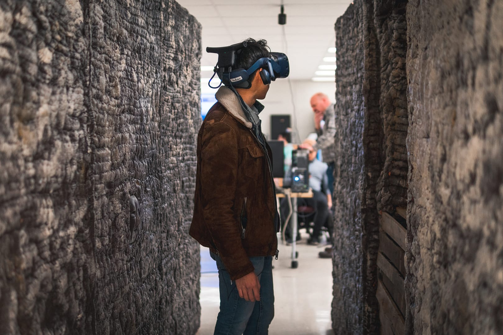
The Virginia Tech team engaged the expertise of students and faculty from numerous departments – Visual Arts, History, Education, Computer Science, Mining, Engineering, and Cinema – to build a life-size model of a tunnel and generate the virtual environment of the battlefield. This allows students wearing VR headsets to ‘walk’ through the scene, experiencing it with both sight and touch.
The speed and accuracy of the ZEB Horizon are game changers for educational and historic preservation VR projects like this because of time and budgetary restraints. VR data processing is extremely time consuming, which means time saved scanning in the field makes grant money go farther in the computer lab. The result is a more realistic and believable experience.
Going further with 3D laser scanning
The Virginia Tech Visualizing History team is not stopping with creating educational experiences from their 3D data collection. They are beginning to apply their VR capabilities to other commercial applications of mobile laser scanning.