Introduced in the 1960s, Lidar technology originally measured large areas of terrain by mounting scanners to airplanes. Similar to radar (Radio Detection and Ranging), this was achievable by emitting pulses toward the surface of the ground and bouncing them back to the sensor. Originally referred to as a "colidar system,” all Lidar-enabled units employ the same concept for measuring and creating 3D models to this day.
It wasn't until the late 1980s and the introduction of commercially viable GPS systems that Lidar data became a useful tool for providing accurate geospatial measurements. Since then, research and development have rapidly advanced and improved Lidar technology.
What is LiDAR?
Lidar is an acronym for Light Detection and Ranging and is a remote sensing method for creating 3D models of the real world.
How Do Lidar Sensors Work?
What Is the Difference between Radar and Lidar?
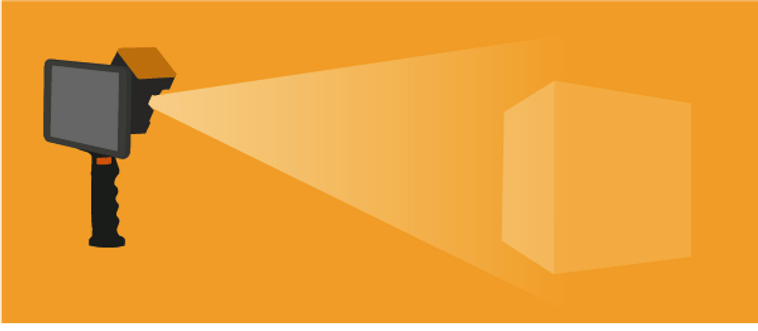
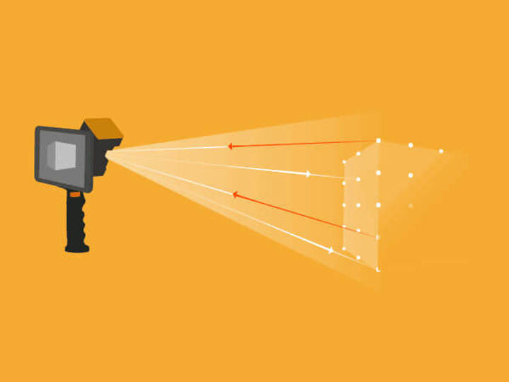
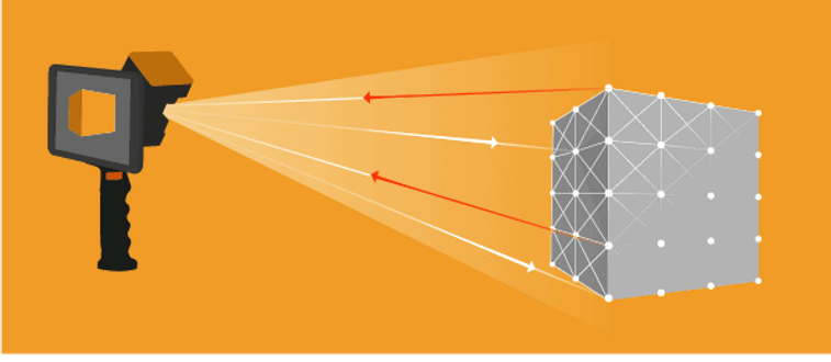
Depending on the sensor, Lidar scanners can emit millions of laser pulses per second. Each pulse returns to the scanner, calculating the distance between the object and sensor using the velocity of light*, referred to as the Time of Flight (ToF). The result is a single point in space and the combination of all these points creates a dense 3D visualization called a “point cloud.”
Lidar and Radar both emit pulses to determine the time it takes to hit a surface and return to the sensor. Radar, however, uses radio waves instead of light pulses. Lidar technology creates accurate measurements through 3D models, whereas the primary use for Radar is for military purposes i.e., on battleships to detect objects in the vicinity.
What Is Lidar Technology?
Lidar technology is an ideal solution for examining the surface of the earth, assessing information about the ground surface, creating a digital twin of an object, or detailing a range of geospatial information. Laser scanning systems harness this technology, using Lidar data to map 3D models and digital elevation.
Lidar mapping uses a laser scanning system with an integrated Inertial Measurement Unit (IMU) and GNSS receiver or a SLAM (Simultaneous Localization and mapping) algorithm, which allows each measurement, or points in the resulting point cloud, to be georeferenced.
Lidar maps give positional accuracy — both absolute and relative, to allow users of the data to know where in the world the mapping took place and how each point relates to objects in terms of distance.
What Can You Use Lidar Systems and Data For?
There aren't many applications that wouldn't benefit from using Lidar. From architecture, engineering, construction, and operation (AECO) to mining and forestry to real estate — 3D models are ideal solutions for a variety of industries. Here are a few examples:
- Terrain Mapping:
- Real Estate:
- AECO:
- Environment:
- Mining:
- Space Travel:
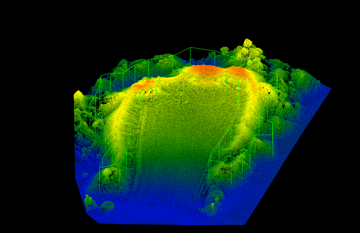
Surveying tasks often require Lidar systems to collect 3D measurements to create digital terrain (DTM) and digital elevation models (DEMs) of landscapes (see below for more information).
Indoor mapping using Lidar is ideal for measuring space and creating accurate floorplans.
Lidar technology is becoming increasingly prevalent in AECO. Tracking building projects and producing digital twins for building information modeling (BIM) applications, plus mapping the built environment like buildings, road networks or railways has never been easier.
Environmental applications for Lidar are plentiful. Laser scanning is a popular method of mapping flood risk, carbon stocks in forestry, and monitoring coastal erosion.
Creating 3D models of mines provides great visibility of progress but can also improve safety through various means like regularly reviewing convergence.
If that wasn't enough, NASA employs Lidar to assist with the landing of lunar vehicles safely on the surface of other planets.
What Are the Different Types of Lidar Scanners?
Since the commercialization of Lidar technology, there have been various iterations of laser scanners with varying pros and cons.
Terrestrial Laser Scanner
Mobile Laser Scanner
Lidar Technology in Phones
The most common and longstanding use of a Lidar sensor for mapping is in terrestrial laser scanners (TLS). A TLS is a static-based solution often on a tripod, emitting hundreds of thousands (in some cases millions) of light beams per second to create dense 3D models.
TLS delivers highly accurate and granular data, which is ideal for applications like crime scene investigation mapping or visualizing construction site progress.
The development of mobile laser scanning devices in recent years has opened opportunities for mapping previously hard-to-reach or impossible places. Though less accurate than a TLS, mobile Lidar is significantly more versatile with the capacity for handheld, UAV, or vehicle-mounted scans. Additionally, SLAM systems do not require GPS to create a digital map, further widening its usability.
Mobile mapping is ideal for industries like mining where speed, accuracy, and ease of capture are a must.
Apple was the first company to introduce Lidar to mobile phones and tablets in 2020. Though significantly less accurate than both mobile laser scanners and TLS, and lacking high levels of range, the development of the iPhone and iPad is a huge step towards getting Lidar into more people's hands.
Working in tandem; TLS, mobile, and Lidar-enabled phones are the perfect solutions for consistent Lidar data capture of the same area over time.
What Is a Point Cloud?
A point cloud is a multitude (often millions) of points within the scans captured by a Lidar scanner. These points represent a point on the surface of, for instance, a scanned building. The scanner automatically combines the vertical and horizontal angles created by the laser beam to calculate a 3D XYZ coordinate position for each point to produce a set of 3D coordinate measurements.
Processing the data creates a digital 3D model that gives an accurate detailed picture of the scanned environment. The denser the points, the more detailed the representation, which provides clarity for smaller features and texture details.
Lidar System for Surveying — What Are the Best Use Cases?
There are many great use cases for Lidar. These include civil engineering and surveying, from highways and roadworks to bridge construction and mapping large retail developments. In fact, Lidar is extensive, allowing surveying firms to be more cost-effective while maintaining the highest level of professionalism. Some great examples include:
Design
Evaluation
Surveying
What Are Digital Elevation Models (DEMs)?
What Are Digital Terrain Models (DTMs)?
Lidar surveying equipment and 3D scanners help civil engineers get highly accurate results in a short space of time. Essential when working with tight timeframes.
Lidar technology is perfect for creating a digital model so you can spot and correct irregularities before building work starts, as well as monitor changes between scans to show progress.
Surveyors prefer Lidar systems to help them create detailed 3D images, accurate digital terrain models (DTM) and digital elevation models (DEMs) of specific landscapes.
A digital elevation model (DEM) is a three-dimensional representation of terrain and all the objects within that space. Regularly spaced elevation values collected from Lidar scans create a coordinate system that allows the earth to be reflected and modeled with a high level of accuracy.
Unlike DEM which considers objects like vegetation, buildings and other artifacts, a Digital Terrain Model (DTM) only considers the surface of the earth. A DTM will include heights and elevations of the surface, including ridges or rivers to give an accurate picture of the terrain.
Lidar Scanning Technology Explained
So, what is Lidar? Hopefully, we've satisfied your curiosity about Light Detection and Ranging. This pulsed laser technology has so many applications for mapping, providing detailed information and data on the environment.
If you're looking for a 3D scanner for a business application, Lidar technology gives you the power to collect the geospatial data you need. Our range of handheld laser scanners uses Lidar and SLAM technology to produce point clouds for many different applications. Contact us for more information and find out what a new Lidar laser scanner could do for you.
Learn more about FARO's mobile mapping solutions here* The velocity or speed of light is 299,792,458 meters per second.