Last Updated on 25th April 2022
Last week we attended the Intergeo Conference in Stuttgart, Germany, for the sixth time. Throughout the three-day event, we found the latest industry innovations, met with customers new and old, and most importantly, unveiled a brand new product of our own. In this blog, Shelley Copsey, GeoSLAM CEO, discusses some of the themes of this year’s show and our brand new product announcement, the ZEB Discovery.
There is no doubt that the geospatial industry is continuing to grow, with more sectors across the globe adopting new technologies, understanding at a deeper level how geospatial data can change their workflows and the bottom line benefit of embracing this rich source of data. This year’s conference really highlighted its influence, showcasing exciting new ideas and solutions to business challenges. A particularly interesting theme was the growth in the number of companies developing their own SLAM based mobile mapping systems – a sure sign that SLAM has gone mainstream.
It’s great to see that more organisations are looking for straightforward solutions and turning to SLAM. Here at GeoSLAM, our algorithm has been commercially available for over 6 years, and like any algorithm, the more it is used in the real world, the more intelligent and robust it becomes. Thousands of GeoSLAM mapping devices exist in the world and are being used every day to map a wide variety of environments: from indoors (be it residential, commercial or medical), to facades and cityscapes, to hard-to-reach, dangerous and remote locations quickly and easily – allowing even the most inexperienced surveyors to produce accurate and highly detailed images within minutes.
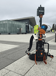
Our latest addition to the ZEB family, the ZEB Discovery, has been developed to help deliver a solution for businesses to quickly survey complex urban environments and integrate accurate point clouds with high-resolution panoramic imagery. You can read more about the ZEB Discovery here. The feedback from Intergeo was amazing, as are the business opportunities it will create for our customer base.
Another key theme at Intergeo was the incorporation of mobile mapping data into production workflows, with the use of this technology going beyond the survey industry and into a broad variety of sectors. Sectors who are experiencing the demand of the customer to provide an answer today, who expect technology to solve problems and not merely provide data. GeoSLAM operates most effectively as a problem-solving organisation, delivering products and solutions which offer genuine value to a range of sectors, whether facilities management, mining or real estate. With over 20 years experience in solving 3D data problems, and a deep understanding of how interconnectivity is reshaping industries, our new GeoSLAM Connect platform will enable our customers to tackle their most difficult challenges.
Finally, our team enjoyed the opportunity to connect with our dealer community at the geospatial industry’s flagship show, and host over 100 people from this community at our annual EMEA dealer conference. It is these connections that enable us to understand the challenges customers face on the ground with 3D data and ensure that our technology remains the best mobile mapping platform to solve the problems of today, and tomorrow.
Interested in learning more about GeoSLAM? Contact us below.


