Last Updated on 25th April 2022
How GeoSLAM’s mobile technology collates forest resource information for Australian National University
Placed first in Australia and 20th in the world, Australian National University (ANU) is a research institution with its main campus in Canberra, the country’s capital. The university’s research priorities typically reflect the challenges facing the world today. One such project is to track tree growth and development over time in a joint effort between ANU and Australia’s Commonwealth Scientific and Industrial Research Organisation (CSIRO).
Known as the ‘Precision Measurement of Trees and Forests’ project, the field team is charged with comparing and contrasting different ways of collecting data, using different terrestrial and airborne laser scanners, and working with digital imagery. The survey takes places in the National Arboretum in Canberra which features some 44,000 rare, endangered and symbolic trees and is made up of 94 mini forests.
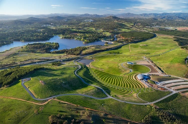
The National Arboretum covers 250 hectares of land within striking distance of Canberra CBD (Image courtesy of Tonkin Zulaikha Greer Architects)
GeoSLAM’s “go-anywhere” mapping technology was a natural choice for the outdoor project. Unlike terrestrial systems, the splash-proof, dust-tight, mobile laser scanners are designed to operate in the most difficult-to-access spaces, inside or outside, in daylight and darkness – without the need for GPS. What’s more, you can easily attach the portable laser scanners to a drone or helicopter for fast outdoor surveying.
In addition to GeoSLAM’s versatile handheld technology, the team also uses fixed point scanning and traditional forestry measures – such as Suunto and digital photographs from UAV’s. Tom Jovanovic, former CSIRO researcher and now Interactive Technology Specialist at the University of Newcastle, Australia, explains that the technologies are complementary, “Using GeoSLAM from the outset, as well as a different system, has enabled us to compare and contrast different measurements and combine them into a heavily monitored site finding. This includes the high level of resolution being sought.”
“What I really like about this product is that wherever you can walk, you can scan. It really is a case of ‘go-anywhere’”
Emphasising that the project is specifically designed to take advantage of both static and mobile approaches, Tom Jovanovic says, “What’s nice about scanning with GeoSLAM’s technology is that it doesn’t involve repeatedly setting up in different locations within the research plot. You just initiate the start-up procedure then walk around the plot covering the trees from different angles.”
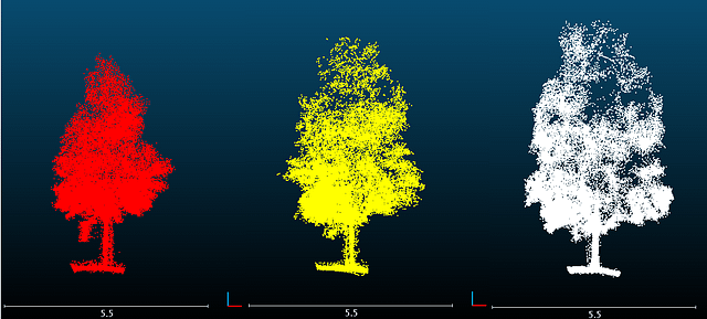
GeoSLAM images depicting the development of a single Spotted Gum (Corymbia Maculata) tree at 12, 24 and 36 months (courtesy of Dr Michael Schaefer, CSIRO Land and Water).
All forestry professionals like Tom need access to user-friendly technology that is easy to operate but is robust and reliable enough to do the job quickly and accurately. With GeoSLAM scanning technology, he says it takes only 10 to 15 minutes to completely cover a 180 square meter plot, adding, “What I really like about this product is that wherever you can walk, you can scan. It really is a case of ‘go-anywhere’. The scanner has made a significant contribution to an important undertaking. Mobile scanning that gives us dynamic changes over time – from any angle and in 3D – is a very important contributor to this work.”
Tom Jovanovic sees the project continuing for some years yet, “We are getting very good results. Using readily available third-party software such as MeshLab and CloudCompare we now have graphics from scanning that goes back several years and allows us to see how the trees have physically grown over that time. With the scans converted by software into mobile 3D images, we can not only view development from different angles but also see how the trees change in terms of stem and branch structure, trunk girth and height of canopy.”
“Mobile scanning that gives us dynamic changes over time – from any angle and in 3D – is a very important contributor to this work.”
These GeoSLAM-delivered findings are vital to the project’s long-term aim. Combining them with knowledge of water usage and photo synthesis, plus meteorological data and high-resolution photography, they feed into very fine scale modelling that will guide forestry research management and habitat protection policies into the future.
Interested in learning more about mapping on the move but don’t know where to start? Why not join one of our informative webinars. Come along for free, our experts cover a range of interesting topics – take a look here.


