Smarter Spaces use GeoSLAM to scan hydroelectric dam


Industry
Asset
Management
Time
1 hour
scanning
total
Location
New
Brunswick,
Canada
Size
3,000 ft
Scanned
Hydroelectric
dam
Canadian 3D geospatial experts Smarter Spaces engaged in a partnership with the University of New Brunswick (UNB) to laser scan a tunnel in a hydroelectric dam – producing a point cloud model to be overlaid with photogrammetry.
The Grand Falls Generating Station is a hydroelectric dam built in 1931 on the Saint John River in the Canadian province of New Brunswick and is operated by the NB Power corporation. The dam’s tunnel is shut down every 4 years for maintenance, inspection, and future life cycle planning.
This presented Smarter Spaces with the opportunity to utilise the mobile, handheld GeoSLAM ZEB Revo to scan the tunnel – creating an accurate point cloud model. In four years’ time the process will be repeated – allowing for the first side-by-side comparisons of the tunnel’s performance to be made.
In addition to this, NB Power has started exploring whether to build a 100-megawatt generating station in Grand Falls to produce more clean energy. The corporation is carrying out environmental and geotechnical studies, site tests, and consultations with First Nations and local residents before applying for an Environmental Impact Assessment later this year.
“It was a simple case of ‘walking and scanning’ through the tunnel environment“
The tunnel is approximately 3,000 linear feet in length and, because of its unique geometry, proposed an interesting set of challenges to scan. The tunnel environment was found to contain a lot of moisture – with a small stream running through the base. The IP67-rated ZEB Revo – which began life in mining environments – is rugged enough for such environments. The tunnel was dark, visibility was low, and walking conditions were slippery and wet. Smooth-sided surfaces also cause data collection issues for mobile scanners.
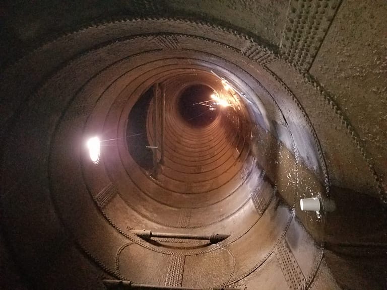
To overcome the risk of data slippage, 4 foot-high pylons were placed every 10 feet in random locations throughout the tunnel. This has the effect of ‘breaking up’ the monotony of the smooth-sided tunnel walls, ensuring that no data slippage occurs.
The scan data was processed in GeoSLAM Hub software to filter, subsample and merge multiple data sets together. The final models and datasets were sent to the University of New Brunswick to support an engineering graduate with their thesis research.


