Last Updated on 30th June 2023
Modern day tools for risk assessment reports provide industries with the means to cost efficiently identify potential hazards, protect assets, and ensure safety to employees and the public. Incorporating mobile LiDAR into the risk assessment process is beneficial for timesaving, improves data visualisation and facilitates informed decision-making.
This article unpacks the potential of mobile LiDAR as a risk assessment tool for revolutionising existing best practices.
Why Risk Assessments Are Important?
Risk assessments are vital in various industries for a series of reasons. Primarily, they serve as a pro-active measure to identify and evaluate potential hazards and risks associated with processes, operations, or environments. A comprehensively conducted risk assessment leads to better anticipation for incidents, accidents, and failures, putting in place measures to mitigate them. Companies that regularly conduct risk assessment reports protect the well-being of employees and customers, whilst protecting valuable assets, equipment, or infrastructure.
A thorough risk assessment report leads to cost savings and operational efficiency. Identifying risks early provides insights for companies to make smarter decisions, implementing control measures to mitigate or eliminate a risk. A better understanding of the importance of risk assessments from employees or customers often leads to greater awareness towards best practices for safety. It also empowers people to confidently report what they perceive to be a risk, potentially mitigating further issues.
Are risk assessments mandatory?
The level of requirement for risk assessments is dependent on industry, country, and the specific regulations in place. In most cases, it is a legal requirement for businesses to conduct risk assessments. Regulatory bodies or government agencies often require organisations to assess and manage risk to ensure the safety of employees, the public, and the environment.
Even industries that have less regulation often conduct risk assessments voluntarily due to the insights they provide. They enhance safety, reduce liability, protect assets, and improve operational efficiency.
Are risk assessments costly?
Depending on the complexity and the resources required, risk assessment tools and reporting can become a costly endeavour for businesses. The cost to complete a report may consider some of the following components:
Expertise
If an organisation doesn’t have the capacity to complete regular risk assessment reports in-house, they may need to look externally for experts in the field.
Tools and technology
There may be a requirement for specialists risk assessment tools, technology, or software, which usually requires more expertise in the equipment.
Time and Resources
A consideration to time and resources when completing a risk assessment report is paramount. This might include allocating staff or personnel to the task.
Follow up
As a result of the risk assessment, companies may need to act on a highlighted issue to mitigate safety concerns.
The growth and speed of capture of mobile LiDAR technology seeks to provide a cost-efficient approach to risk assessments, with the above concerns in mind.
The implementation of mobile LiDAR as a risk assessment tool
Mobile LiDAR solutions have the capacity to be utilised for various risk assessments applications, whether it be fire safety or evacuation planning. Here are a few examples of common applications of LiDAR as a risk assessment tool.
Baseline data analysis
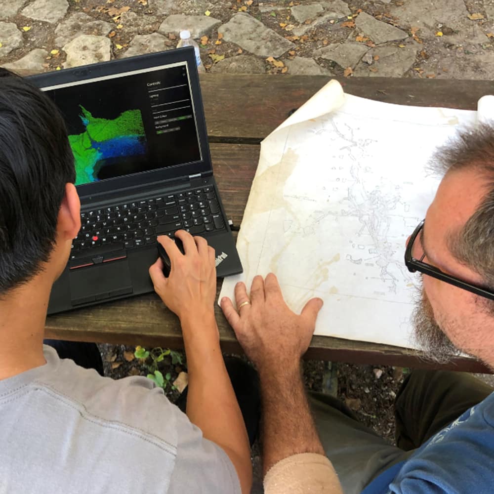
Organisations can gain insights into the changes of a mapped area over time through repetitive scans and comparison to a baseline scan. Traditionally, this would be difficult due to the cumbersome nature of scanning, however the introduction of mobility opens the possibility for repeat scanning as often as needed. Frequent mapping creates the opportunity for reviewing change over time, manually or automatically through software like GeoSLAM Connect. The benefits of this are the ability to review changes like topography, vegetation growth or structural alterations in the infrastructure.
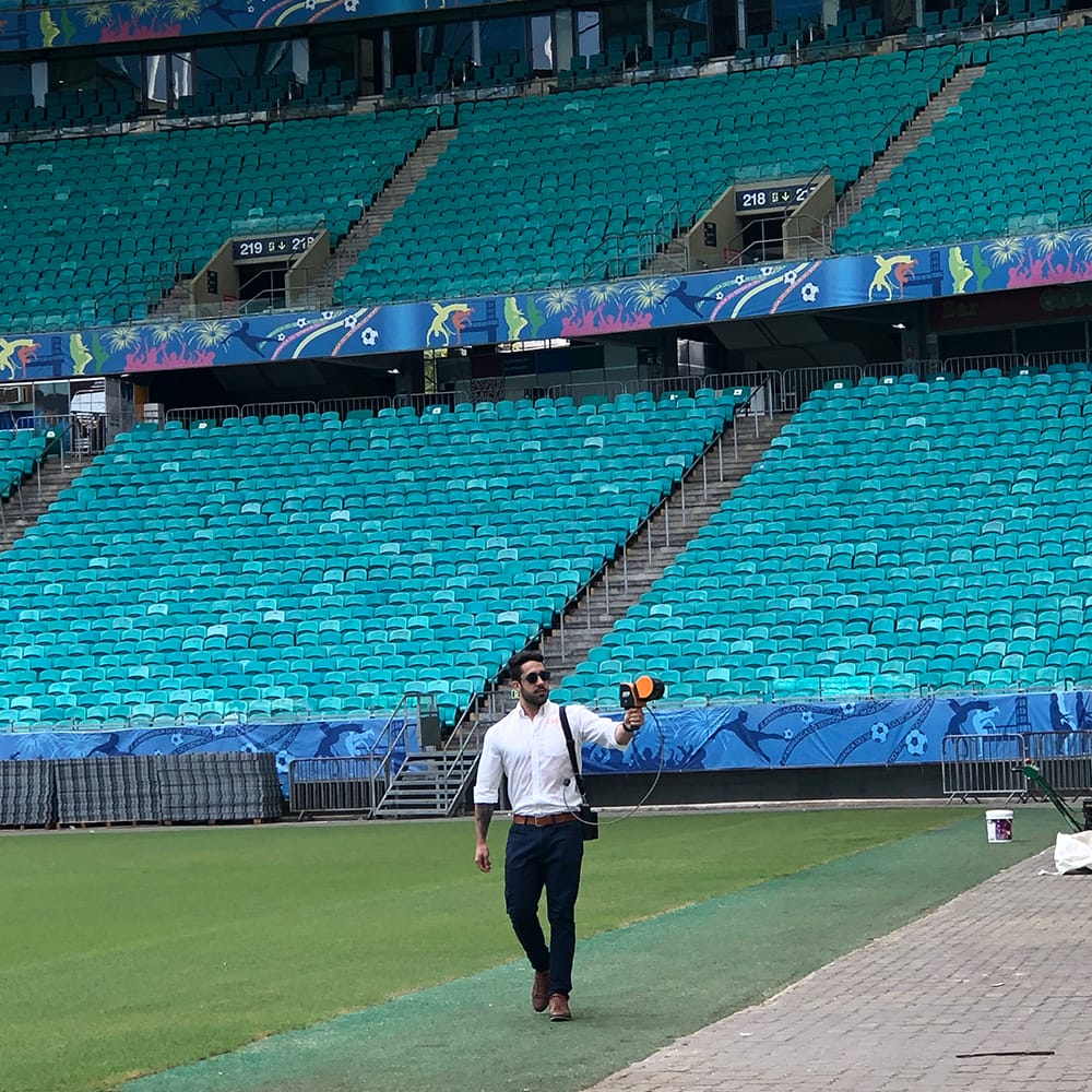
Change detection doesn’t just have the capacity to highlight change in environment, but also of additions to an environment for safety concerns. Having a baseline scan of a stadium, for example, means that a quick review of the same area will highlight any unwanted items objectively, improving crowd safety.
Fire risk assessments
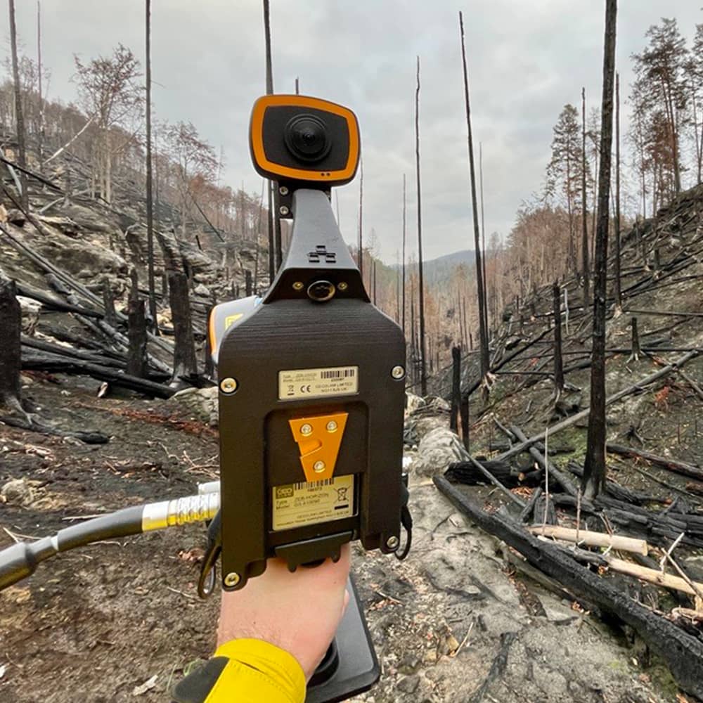
Mobile LiDAR technology offers significant benefits for fire risk assessments. It allows for accurate and detailed 3D maps of the environment, capturing information about topography or vegetation density. The data helps to identify potential fire hazards, assessing fuel loads and understanding the possible spread of a fire in a specific area.
The versatility of mobile LiDAR means that where you can walk you can capture data, not restricting users to a fixed position. In the case of forests, for instance, you can walk through the forest capturing the data and then fly over to capture the canopy. The speed of capture and versatility make mobile LiDAR an ideal risk assessment tool in this field and for these applications, saving lives through mitigation of fire spread.
Evacuation planning
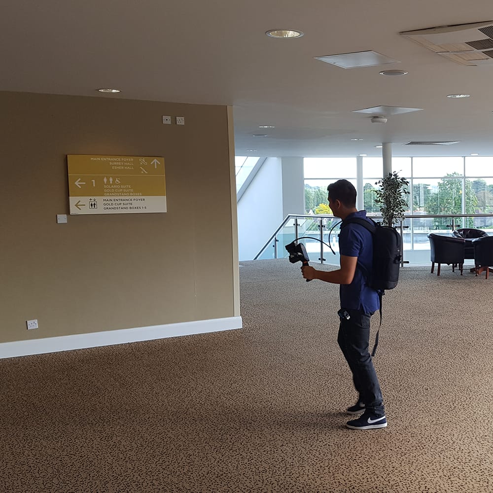
Buildings like hotels or schools require up-to-date floorplans with information about emergency exits, access routes or fire safety equipment. In the case of a fire or other unexpected incidents, the public needs this information to understand the best route to safety from their current position. In most countries, hotels will provide a map of the floor on the back of the room door. Any structural changes to the building’s layout would mean a requirement for up-to-date maps, which isn’t a simple task and would often require a shutdown of the space to capture data.
Mobile LiDAR scanning solves this issue because surveyors can capture data quickly, without disruption to clients. Data capture is repeatable and provides customers with peace of mind that the details provided by the owner are accurate. Scanning with mobile LiDAR can easily cover hallways, rooms, stairwells, and any public areas in a matter of minutes.
Emergency Services
Like evacuation plans, up-to-date information of buildings or area layouts provides emergency services with a better understanding of the building before entering. In the case of a fire, firefighters will need to understand the access route, exits and entrances, as well as the number of rooms/floors. In other examples, mapped areas of complicated caves, mines or urban areas might provide better insights during rescue missions or post disaster events.
These are just a few examples where 3D point cloud data is ideal for risk assessment reports. Other more niche examples might include reporting flood mapping, urban planning, engineering, or natural disasters.
The versatility of mobile LiDAR as a risk assessment tool
Unlike other methods of data capture, mobile LiDAR devices offer a versatile approach to mapping an environment. Scanners like the GeoSLAM ZEB Horizon are mountable to a variety of accessories, providing wider use of the scanner outside of traditional surveying equipment.
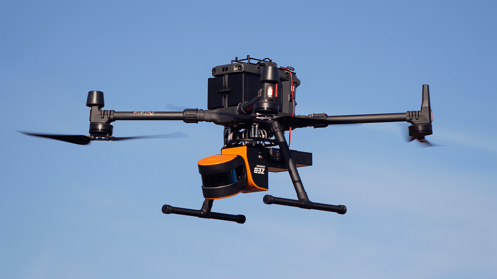
Drone
By mounting the mobile scanner to a drone, surveyors have the means to capture data from a wider area very quickly, which can be merged simply with any other handheld data previously captured.
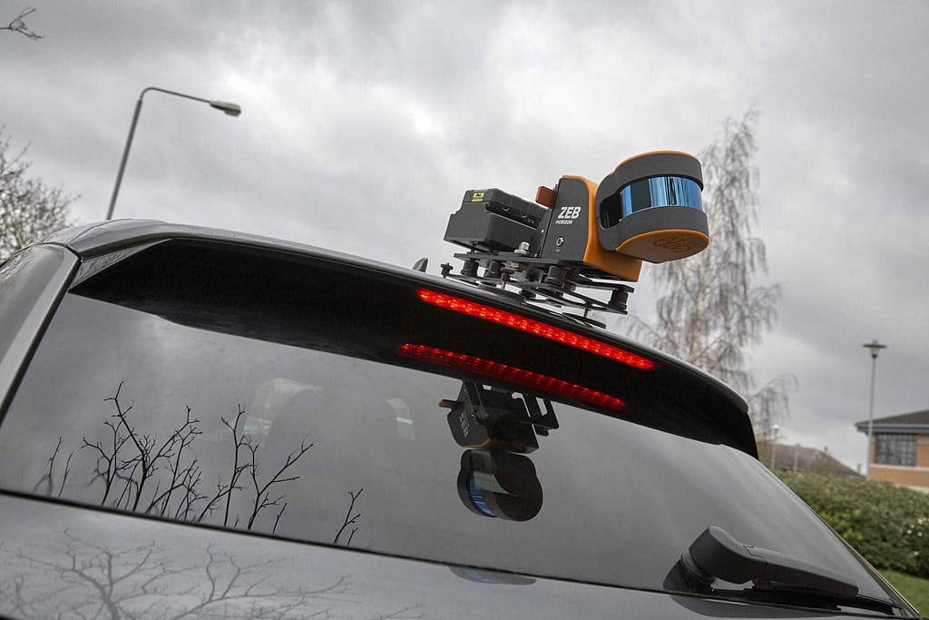
Vehicle
With the capacity to map up to 30mph (48kph) with SLAM, safely mounting mobile LiDAR devices to vehicles provides an option for capturing roads, powerlines, or overgrown vegetation on a much larger scale.
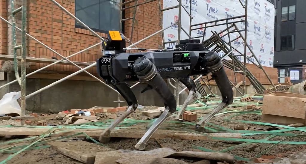
Remote access
Attaching the mobile LiDAR device to autonomous vehicles makes capturing places like construction sites or mine tunnels simple, with minimal effort to a surveyor.
How GeoSLAM’s LiDAR is an ideal risk assessment tool
Mobile LiDAR solutions provide a series of benefits when it comes to creating digital replicas of the real world. These include the following:
Is Mobile LiDAR an ideal tool for risk assessment reporting?
Depending on the requirements of the risk assessment report, mobile LiDAR has the capacity to provide insights for a variety of different applications. The speed of capture, ease of use and repeatability of mapping with mobile LiDAR opens opportunities for cost effective ways of surveying, gathering information needed for the final reports. GeoSLAM has over a decade of expertise in SLAM solutions, and as such has experience with customers in a variety of sectors looking to improve risk assessment tools and technology.
Though traditional ways for mapping will always have a place in surveying, those that don’t consider mobile LiDAR as an option will miss out on the opportunity for innovative technology that improves risk assessment reporting.
Get in touch
If you’d like to learn more about how GeoSLAM solutions can help you, submit the form below.


