Control points are points within a given area that have known coordinates. They are a key tool in the geospatial industry and can be utilised in a variety of ways, including georeferencing point clouds and aligning aerial images to terrestrial data. By using control points, surveyors are able to accurately map larger areas and position overlapping surveys of an area together. They can also be used in non-geospatial industries, such as construction and mining, to show clear temporal comparisons between multiple surveys of the same area. This method of georeferencing is also referred to as adjust to control.
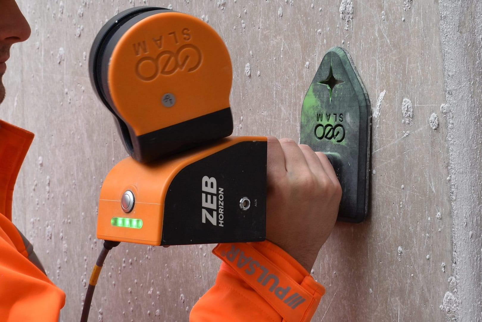
Previously, checkerboards and spherical targets have been used as control markers – these items are captured in surveys and can be identified for georeferencing or aligning. The main drawback with these methods is that they rely heavily on human interpretation when processing, meaning that the processed datasets may be susceptible to an increased amount of error.
When capturing handheld surveys, GeoSLAM systems are able to collect reference points. These can then be matched with known control points to reference scans and increase the level of accuracy.
What makes GeoSLAM referencing different?
More accurate: GeoSLAM scanners are used with known control points and survey grade pins, rather than more traditional moveable targets. This reduces the margin of error within point clouds.
Save time: using known survey control points means there is no need to manually position individual targets before every scan. Data capture can then be repeated regularly, faster, easier and with no concerns that reference points are captured in different places each time.
Safer: in dangerous or inaccessible areas, targets are not required to be physically positioned on pre-defined control points prior to each scan. This reduces the time exposed to hazards and unsafe areas.
Industries using control points
Geospatial
Easily reference point clouds and produce reports highlighting accuracy values.
Mining
Regularly monitor site operations (e.g. stockpiles) and hazards.
Construction
Compare changes over time and map progress onto predetermined CAD/BIM models.
Using control points with GeoSLAM
Capture
All GeoSLAM ZEB systems are able to capture reference points using the reference plate accessory. These reference points can simply be measured by remaining stationary for periods during a scan and will be recognised during the processing stage. Points can be captured from a horizontal or vertical position, depending on which ZEB system is used, making it easier than ever to georeference datasets.
Process
Using the Stop & Go Georeferencing workflow in GeoSLAM Connect, datasets can be automatically referenced through a rigid or non-rigid transformation.
Rigid Transformation
Scans are rotated and adjusted and reference points are matched to the known control points without changing the scale factor. A single transform is applied to every data point in the point cloud.
Non-Rigid Transformation
The scale factor of datasets is altered to suit the control points – every data point is moved to a new position; this means the relative positions of these points also changes. This method is better suited for poor SLAMenvironments.
A clean georeferenced point cloud is produced using both methods. An accuracy report of the transformation is also generated and includes an RMS error value.
Point clouds with endless possibilities
Once georeferenced using control points, point clouds can be optimised further using leading third party software:
Comparisons with existing CAD/BIM models
Point cloud to point cloud registration showing changes over time within a given area
CAD/BIM model creation
For more information about our third party partnerships, head to our integrations page.
Case Study
Mapping hazardous mines under intense time constraints
Beck Engineering, an Australian mining engineering consultancy specialising in mining and rock mechanics analysis, needs to rapidly map mines under intense time constraints using versatile technology which is adaptable to any environment. GeoSLAM’s handheld mobile mapping solution was chosen as it is compact, portable and delivers a high level of accuracy. With GeoSLAM’s “go-anywhere” 3D technology in hand, Beck Engineering has been able to supply invaluable data regarding the direct effects of mining to better understand the implications of a deforming rock mass. Beck Engineering is now able to accurately measure the shape of an excavation or tunnel over time. As a result, tunnels are safer, better designed and more cost efficient.
We have continued to use GeoSLAM products as they have proven to be affordable, lightweight and sufficiently robust devices for their application underground. GeoSLAM continues to produce a high-quality device that is at the forefront of practical mobile laser scanning devices. – Evan Jones, Senior Rock Mechanics Engineer at Beck
If your internet connection allows, move the Point Budget slider to the maximum amount available to view all the points in the cloud.
Making the point size smaller using the Point Size slider makes the data easier to view and interpret.
In the tools section of the viewer, you can measure the distance and angles of features within the pointcloud.
Using the materials section of the viewer, you can use the Select Attributes dropdown to view by intensity, elevation and RGB (if pointcloud is coloured)
UK payment plan
UK payment plan info
USA Payment Plan
Coupling with hardware
Some SLAM software algorithms have been made available as open-source on the internet, but they are purely algorithms and not a product that you can take and use off-the-shelf. SLAM is most successful when it is tightly coupled and designed with specific hardware in mind. A generic SLAM cannot perform as well as one that has been specifically designed for a purpose.
Usage in multi-environments
Visual SLAM is closer to the way humans navigate the world, which is why it’s popular with robotic navigation. But in the same vein, vSLAM will have the same image-capture challenges as humans do, for example not being able to look into direct sunlight, or not having enough contrast between the objects picked up in the image. These can be overcome indoors, however, you may need to map a forest, tunnel or urban canyon. While SLAM technologies don’t rely on remote data (meaning you can scan areas where there is no GPS), you do need to ensure the SLAM technology you chose operate well inside, outside, in daylight and darkness.
Real-time data capture
Mapping a property is time-critical. Ideally, you want to make a single visit and gather sufficient data to create a highly accurate 3D model. Ensure the software you choose transforms 3D point cloud data into actionable information in real-time. This allows you to view and interrogate your data whilst still in the field, and make any adjustments, or collect missed data, then and there.
Flexibility and deployment
If you’re trying to map an enclosed environment (e.g. tunnel, mine) or a complex, difficult-to-access space such as a heritage building with tight stairwells and uneven floors, you need to use fully-mobile, adaptable technology. Wheel-based systems, often used with the vSLAM camera, will struggle with access. Handheld devices or LiDAR scanners that can be attached to a drone or pole and still deliver accurate results in a rugged environment are best for navigating hazardous spaces.
Speed and accuracy
While vSLAM is able to provide a qualitative high-level map and sense of the surrounding features, if you’re needing survey-quality accuracy and rich-feature tracking at a local level, you’ll need to consider LiDAR. Cameras require a high-frame-rate and high processing to reconcile data sources and a potential error in visual SLAM is reprojection error, which is the difference between the perceived location of each setpoint
and the actual setpoint.
Quality and distortion
In order to deliver the depth required for high-quality data, a number of depth-sensing cameras are needed with a strong field of view. In most cases, this isn’t possible, especially as cameras with high processing capabilities typically require larger batteries which weigh down airborne scanners, or limit the time of flight. LiDAR is both faster and more accurate than vSLAM, and can deliver detailed point clouds without expensive (and timely) camera processing.